
Upper Schalke Pond
| Upper Schalke Pond | |||||||||
|---|---|---|---|---|---|---|---|---|---|
.JPG) |
|||||||||
|
|||||||||
|
|||||||||
| Coordinates | 51 ° 50 '27 " N , 10 ° 23' 13" E | ||||||||
| Data on the structure | |||||||||
| Lock type: | dam | ||||||||
| Construction time: | 1733 | ||||||||
| Height above valley floor: | 14.35 | ||||||||
| Height of the structure crown: | 549.50 | ||||||||
| Crown length: | 85 m | ||||||||


The Obere Schalke Pond was a small dam that was created in connection with the Upper Harz water shelf near Schulenberg in the Upper Harz . As a ground monument, the former dam is part of the world heritage site of the Rammelsberg mine, the old town of Goslar and the Upper Harz water management system .
Naming
The building takes its name from the Schalke stream of the same name , which is dammed here. The stream is named after the mountain of the same name, Schalke , from which it rises. The corresponding valley is also called Schalketal .
history
The pond was created in 1733 to supply water to the pits and stamping mills below, to which the water was partially fed with ditches. There was a smaller predecessor pond, laid out in 1711, the dam of which was routed about 80 meters further above (north). This previous dam was completely removed and its material used for the construction of the new Upper Schalke Pond.
The dam must have been taken out of service in the 19th century. In an inventory from 1866 it was already marked as "out of service". The reasons for the shutdown were possibly technical problems (leaks), but on the other hand also decreasing water requirements of the mines to be supplied. The impressive remains of the dam form ground monuments and thus belong to the passive systems of the Upper Harz water shelf.
The dam was not properly dismantled at the time. Obviously you just left the bottom outlet ( harrow ) open. The wooden pipe weathered over the centuries, but remained water-permeable, so that the system was only dammed during very rare floods. A digging of the dam was started but not finished.
Dam burst 2017
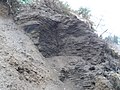
On July 26, 2017, the residents of Oberschulenberg were temporarily evacuated because, after prolonged heavy rainfall, the dam of the Upper Schalke Pond, which was actually out of service, broke and a strong tidal wave flowed into the Lower Schalke Pond . Presumably, the dam system was dammed up, overflowed and very heavily seeped through due to the very high inflows. After the first break, trees and parts of the seal on the embankment fell into the embankment and caused a new damming. In total, eyewitnesses observed three tidal waves that then streamed through the Lower Schalke Pond and finally through Oberschulenberg. The breach of the dam made the inside of the dam clearly visible, in particular the core seal made of turf was easy to see and still gave a functional impression. As a result of investigations, the Mining Archeology Unit of the Lower Saxony State Office for Monument Preservation suggested in 2018 that the dam be left in the shape it remained after it broke.
Others
Below the Upper Schalke Pond there was the Middle Schalke Pond, which must also have been abandoned in the 19th century. A little further down is the Lower Schalke Pond , which is still in operation today. Since it has been the only one of three Schalke ponds since the middle of the 19th century, it is often simply referred to as the “Schalke pond”.
See also
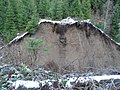
View of the northeast part of the dam.

The top of the dam of the Schalke Pond seen from the south-western slope
Well-preserved sod seal in the dam core

Scree avalanche below the dam after dam break
.JPG)
.JPG)
.JPG)

literature
- Martin Schmidt : The water management of the Upper Harz mining (= publication series of the Frontinus Society . Issue 13). 3rd supplemented edition. Harzwasserwerke, Hildesheim 2002, ISBN 3-00-009609-4 .
- Justus Teicke, Katharina Malek , Der Bruch des Oberen Schalker Teichdammes in July 2017 in: Our Harz, history and stories, culture and nature from the entire Harz, Oberharzer Druckerei and Verlag Fischer & Thielbar GmbH, Clausthal-Zellerfeld, issue 6/2020, Page 103 ff
Web links
Individual evidence
- ↑ Martin Schmidt: The water management of the Upper Harz mining industry . 3. Edition. Harzwasserwerke GmbH, Hildesheim 2002, ISBN 3-00-009609-4 (series of publications by the Frontinus Society, issue 13).
- ↑ Martin Schmidt: WasserWanderWege, a guide through the Upper Harz water shelf - world cultural heritage . Ed .: Harzwasserwerke GmbH. 4th edition. Papierflieger Verlag, Clausthal-Zellerfeld 2012, ISBN 978-3-86948-200-2 , p. 232 .
- ^ A b Alfred Dumreicher: Entire overview of the water management of the north-western Upper Harz . 1st edition. Oberharzer Geschichts- und Museumsverein eV, Clausthal-Zellerfeld 2000, ISBN 3-9806619-2-X (new edition of the original from 1868).
- ↑ a b c d e Justus Teicke, Katharina Malek, Der Bruch des Oberen Schalker Teichdammes in June 2017 in: Our Harz, history and stories, culture and nature from the entire Harz, Oberharzer Druckerei and Verlag Fischer & Thielbar GmbH, Clausthal-Zellerfeld , Issue 6/2020, page 103 ff
- ^ Andreas Rietschel: Oberschulenberg is being evacuated. In: Goslarsche Zeitung Online. July 26, 2017. Retrieved August 2, 2017 .
- ↑ Grass should grow about the consequences of floods in Goslarsche Zeitung of November 8, 2018