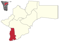
Okahandja (constituency)
 Details |
Okahandja constituency |
| Basic data | |
|---|---|
|
State region |
Namibia Otjozondjupa |
|
Population area District administrative seat |
24,451 5856 km² Okahandja |
| Election information | |
|
Registered voters |
|
Okahandja is a constituency in the Namibian region of Otjozondjupa . It includes the city of Okahandja , after which it is named. With an area of 5856 square kilometers and 24,451 inhabitants (2011). It is one of the smallest constituencies in Namibia in terms of area .
Web links
- Official constituency page (English)
Individual evidence
- ^ Otjozondjupa 2011 Census Regional Profile. Namibia Statistics Agency , 2011, p. Ii and p. 4.
Coordinates: 21 ° 51 ′ S , 16 ° 45 ′ E

