Orava (municipality)
| Orava | |||
|
|||
| State : |
|
||
| Circle : |
|
||
| Coordinates : | 57 ° 54 ' N , 27 ° 28' E | ||
| Area : | 175.6 km² | ||
| Residents : | 816 (11.2009) | ||
| Population density : | 5 inhabitants per km² | ||
| Time zone : | EET (UTC + 2) | ||
| Postal code : | 64101 Orava | ||
| Community type: | former rural community | ||
| Website : | |||

|
|||
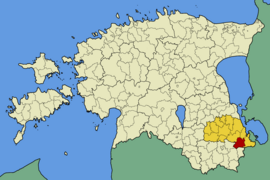
Orava (German: Waldeck ) is a former rural community in the Estonian district of Põlva with an area of 175.6 km². It had 816 inhabitants (as of November 5, 2009). As part of the municipal reform in 2017, Orava became part of the rural municipality of Võru and moved to Võru County .
geography
Orava is 285 km from Tallinn and 42 km from Põlva . In addition to the main town of Orava belonged to the rural community of the villages Hanikase , Yantra , Kakusuu , Kamnitsa , Kliima , Kõivsaare , Kõliküla , Korgõmõisa , Kovera , Lepassaare , Liinamäe , Luuska , Madi , Marga , Oro , Pääväkese , Päka , Piusa , Praakmani , Rebasmäe , Riihora , Rõssa , Soe , Soena , Suuremetsa , Tamme , Tuderna and Vivva .
Orava is known for its diverse nature. The four lakes Orava, Solda, Mustjärv and Kõvera as well as the forests invite you to relax. One of the largest deposits of quartz sand in Estonia is located near the town of Piusa .
Web links
- Orava municipality website (Estonian)

