Ossetian Heerstrasse
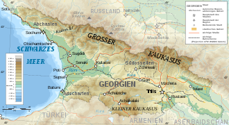
Ossetian Army Road is the historical name of a road across the Greater Caucasus . It connects Alagir in Russia with Kutaisi in Georgia and is 270 kilometers long.
The military road follows the Ardon Valley in North Ossetia-Alania in a south-westerly direction, crosses the main Caucasus ridge at the Mamisson Pass at 2820 m above sea level, leads down into the valley of the Rioni River to Oni and follows the river via Ambrolauri to Kutaisi , the capital of the Imereti region .
The road was built in 1889 by the Russian army as the second major military road through the Caucasus. At first it was an unpaved path that was supported by stones at the side. Later it was expanded several times, provided with river bridges and an asphalt surface. In addition to the Georgian Army Road , which ran to the east, it was the most important north-south connection across the mountains until the 1980s. The road is hardly used today. The eastern Transcaucasian trunk road with the Roki tunnel has taken over its tasks , but since the Caucasus War in 2008 only between Russia and South Ossetia .

