Otter Tail River
| Otter Tail River | ||
|
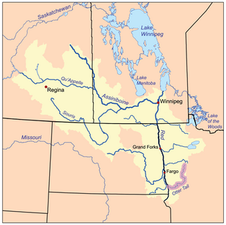
Catchment area of the Red River of the North, the Otter Tail River is highlighted |
||
| Data | ||
| Water code | US : 657701 | |
| location | Minnesota (USA) | |
| River system | Nelson River | |
| Drain over | Red River of the North → Nelson River → Hudson Bay | |
| source | in Clearwater County (Minnesota) 47 ° 1 '39 " N , 95 ° 32' 40" W |
|
| confluence | with the Bois de Sioux River to the Red River of the North Coordinates: 46 ° 15 ′ 52 " N , 96 ° 35 ′ 55" W 46 ° 15 ′ 52 " N , 96 ° 35 ′ 55" W |
|
| Mouth height |
289 m
|
|
|
Sunset on the Otter Tail River near Otter Tail Lake at Ottertail |
||
The Otter Tail River is a river in the middle of the US state of Minnesota . Its source is in Clearwater County near Bemidji . It then flows through a number of lakes and towns in Minnesota. These include Elbow Lake , Many Point Lake , Chippewa Lake , Height of Land Lake , Frazee , Little Pine Lake , Big Pine Lake , Rush Lake , Otter Tail Lake, and Ottertail , West Lost Lake , Fergus Falls, and Orwell Lake . Together with the Bois de Sioux River, after its confluence, it forms the Red River of the North .
Web links
Commons : Otter Tail River - Collection of Images, Videos and Audio Files

