Palliser triangle
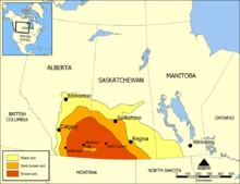
The Palliser's Triangle ( English Palliser's Triangle ) in Canada is a geographic region of southern Saskatchewan and Alberta . The triangle extends from Red Deer in the north to the US border in the south. It is named after John Palliser , whose expedition mapped western Canada between 1857 and 1861.
When Palliser discovered the area, it was largely arid and completely treeless. He said the area was unsuitable for agriculture . However, a few years later, government official John Macoun claimed the land was perfectly suitable for growing wheat and convinced immigrants to settle here. The triangle was finally settled at the beginning of the 20th century.
Yields were good for a while, but the combination of periods of drought and backward farming practices resulted in severe erosion and increased sandstorms known as the Dust Bowl in the 1930s . Agriculture was only able to re-establish itself thanks to the introduction of modern cultivation methods and numerous rainy years. To this day, however, agriculture has remained a highly uncertain affair, and farmers often rely on large subsidies to survive periods of drought. However, locally there are regions such as the Regina Plains , which are characterized by their excellent suitability for arable farming.
Individual evidence
- ^ J. Mitchell, HC Moss, JS Clayton (1987): Soil Survey of southern Saskatchewan from township 1 to 48. University of Saskatchewan, College of Agriculture.
- ↑ http://www.geostrategis.com/c_cli-regina.htm
