
Parade (Lübeck)


The parade is a street in Lübeck's old town .
location
The approximately 140 meter long parade is located in the south-western part of the old town island, the Marien Quartier . It begins at the meeting of Dankwartsgrube , Horsemarkt and Kapitelstraße , runs south and ends in front of the Zeughaus , where the Domkirchhof , Hartengrube and Großer Bauhof meet .
history
For a long time, today's parade was not seen as a separate street. Rather, it was originally part of the Sand Road , and when its southern section was permanently viewed as a separate road as a horse market after 1456 , the parade was now part of it.
Due to the daily parade of the Lübeck city military in front of the armory since the beginning of the 18th century, the term parade for the southern end of the horse market became established, and in 1852 this name was officially established. Due to its location between the Garrison Church and the Catholic Church, the military also use it afterwards. From 1901 to 1912, was Rantzau Castle seat of the rod of the 81st Infantry Brigade .
All the land and buildings on both sides of the parade were originally canons - curiae . After the dissolution of the cathedral chapter as a result of secularization , they fell to the city of Lübeck in 1804, but the right of residence for life remained with the former canons.
Buildings
- Parade 1, Rantzau Castle . Neo-Gothic palace from 1858, into which a Gothic back gable from the 15th century was integrated.
- Parade 4 , the neo-Gothic Catholic Church of the Sacred Heart of Jesus, built 1888–1891.
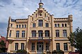
Rantzau Castle

Parade, view from the armory in north direction to the horse market

The Catholic Church is still standing unharmed on the street Parade. Photo taken around 1900.


literature
- W. Brehmer : The street names in the city of Lübeck and its suburbs. HG Rathgens, Lübeck 1889.
- W. Brehmer: Lübeck house names along with contributions to the history of individual houses. HG Rathgens, Lübeck 1890.
- Klaus J. Groth : World Heritage Lübeck - Listed Houses. Over 1000 portraits of the listed buildings in the old town. Listed alphabetically by streets. Verlag Schmidt-Römhild, Lübeck 1999, ISBN 3-7950-1231-7 .
- Max Hoffmann: The streets of the city of Lübeck. In: Journal of the Association for Lübeck History and Archeology. Jg. 11, 1909, ISSN 0083-5609 , pp. 215-292 (also special print 1909).
Web links
Coordinates: 53 ° 51 ′ 44.8 ″ N , 10 ° 41 ′ 6 ″ E