Parc national des Hautes-Gorges-de-la-Rivière-Malbaie
|
Parc national des Hautes-Gorges-de-la-Rivière-Malbaie
|
||
|
The Malbaie |
||
| location | Lac-Pikauba ( Québec ), Canada | |
| surface | 224.7 km² | |
| WDPA ID | 555567059 | |
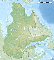
| Geographical location | 47 ° 56 ′ N , 70 ° 31 ′ W | |
|
|
||
| Setup date | 2000 | |
| administration | Parcs Québec | |
The Parc national des Hautes-Gorges-de-la-Rivière-Malbaie ( French for "National Park of the Deep Gorges of the Malbaie") is one of the current 27 national parks in the Canadian province of Québec . There a parc national corresponds to what is called a provincial park in the other provinces . The park is operated by Sépaq ( French Société des établissements de plein air du Québec or English Society of outdoor recreation establishments of Quebec ).
It has an area of 224.7 km² and is accessible via the village of Saint-Aimé-des-Lacs . The park is also part of the Charlevoix Biosphere Reserve by UNESCO . The park also encloses the Réserve écologique des Grands-Ormes , a separate protected area for the huge elms standing there. It is maintained by the Québec government through the Société des établissements de plein air du Québec (SÉPAQ). The park is home to largely untouched stands of sugar maple and American elm - both of which are some of the northernmost habitats of these species.
Location and landscape
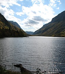
The protected area hides the river valley of the Rivière Malbaie , which is located in a low mountain range with rockfalls up to a height of 800 m. It also has numerous rapids and waterfalls, the highest of which plunges 350 m. This is known as the Pomme d'Or and is often visited by alpinists in winter when the waterfall is frozen. At 1048 m , the Acropole des Draveurs is the highest mountain, followed by Mont des Érables ( 1030 m ), the summit region of which is covered by permafrost .
The Malbaie has its source in Petit Lac Tristan at a height of about 900 m, a small lake that is already close to Québec , and after 168 km it reaches the St. Lawrence River at La Malbaie . At the end of the last ice age, the Malbaie fell immediately into the bay Ha! Ha! . The Malbaie ('bad bay') got its name because the unfavorable flow conditions at the confluence of the river with the St. Lawrence River made it difficult for boaters to anchor.
history
The Indians of the region, who built a passage for canoes into the great river at the mouth, named the river Babapimish-Kamagou. They lived from fishing and hunting, with caribou being of great importance. In the 17th and 18th centuries, they hunted the beaver to sell its fur to the French and English.
Mammals typical of the boreal forests of Northeast America, such as beavers and wood caribou, can be found in the more remote areas of the park. When fishing for salmon, as the Europeans reported in the 16th century, the indigenous people used torches that were attached to the bow of the boats that sailed out at night. In 1656 Jesuits reported that Guillaume de l'Espinay from Tadoussac had caught a thousand fish in a single day at the mouth of the Malbaie.
The area was part of a seigneurie , a feudal manor whose residents were obliged to serve (corvées) and pay taxes. Therefore, the master of the seigneurie, John Naime , could demand that a certain proportion of the salmon that had been caught using the said technique be given to him. But the French refused to allow him to do so, and an agreement was only reached through the mediation of the pastor of La Malbaie. Naime, Scot and Protestant, wanted to turn his seigneury into a Scottish enclave. Therefore he tried to recruit settlers from his homeland. A few came, such as Hugh Blackburn and Duncan Mac Nicoll, but they soon spoke French and adapted to the local indigenous and French-dominated culture. Until his death in 1801, Naime argued with his Catholic, French-speaking subjects.
From 1771 the settlement of the Malbaie began formally. Corresponding concessions were issued, but it was not until 1784 that settlers arrived on the northeast side of the river, and in 1795 at the waterfall near what is now Clermont. A first settlement concession followed in 1807 for Saint-Aimé-des-Lacs , in 1812 for Lac-Naime , from 1823 the new settlers were allowed to continue building houses in the hinterland. The area of the deep ravines remained uninhabited as agriculture was not possible there. In 1830 a settlement company was established, the Société des Vingt-et-un , the Society of Twenty-One , which was supposed to ensure further immigration. Their guide was the trader Alexis Tremblay, known as Picoté. On the initiative of the 21, a path from La Malbaie to Grande Baie was to be created. This path, created between 1847 and 1849, led from Sainte-Agnès over Lake Naime, then along the Malbaie to Lac Basile , then over Lac de la Souris , Lac Brébeuf and Lac Otis to the Grande Baie. Initially only intended as a mail route, from 1861 vehicles could drive the entire route. The steep slope in the area of Lac Basile, however, made a forest path out of the way.
The region has long been considered remote, self-sufficient and backward, which led some of the grain farmers to try dairy cattle. This succeeded and a renowned company emerged with the Crèmerie Bhérer . On the Chute Naime , the Naime Fall, a cheese factory was established that produced Cheddar and Gruyère in the 1930s . In addition, a local turkey specialty was turned into an export product that was particularly popular in New York , Murray Bay Turkey - derived from La Malbaie. Otherwise carrots, potatoes or peas flourished, pigs and cattle were bred, as well as chickens, turkeys and geese.
The dissolution of feudal rule came late in Québec because its continued existence was part of the agreements the British had made when they took over colonial rule and involved the French-speaking population in London's wars with the United States. It was not until 1845 that Malbaie was established as the first commune. The district of Pointe-au-Pic, which had grown due to the emerging tourism, broke away from the association in 1876. The village of the same name was created from the remaining part of Malbay. In 1911 the district of Cap-à-l'Aigle separated from the municipality and also became an independent municipalité. In 1935 the comunauté Clermont was finally established and three years later Rivière Malbaie, so that the originally large commune had split up into several places that were too far apart to be subject to a common administration. Sainte-Aimé-des-lacs also separated from Sainte-Agnès in the hinterland. However, this development was reversed at the end of the 20th century when communication conditions allowed it. In 1995 Malbaie merged with the municipality of Pointe-au-Pic and in 1999 with La Malbaie; however, Clermont remained independent.
The winding river was used for a long time to float the trees that were felled further above and which reached the St. Lawrence River . As early as the 1830s, men felled trees for Alexis Tremblay di Picoté, which were mainly sold to William Price in Québec. Price prevented the Twenty-One Company from going its own way in this sector by buying up its assets. Only he was allowed to control the trade in wood for the English fleet. In 1902 a dam was built on the Naime Falls for electricity production by the Labrador Electric and Pulp Company, followed by a paper and pulp mill in 1911, because the forests now supplied less wood for shipbuilding and house construction than for paper. The factory was taken over in 1920 by the Donohue brothers, whose name the company bore from then on. In 1936 the industrial settlement of Clermont was established in this area. For more than half a century from 1911 onwards, salmon, which had previously been so abundant, disappeared from the region.
The rafting (drave) did not end until 1987. 1996 the trips of the tourist ships on the Malbaie were stopped.
literature
- Serge Gauthier, Guy Godin: Raconte-moi ... la rivière Malbaie . Presses Université Laval, 2004.
- The research scientifique dans les Parcs nationaux québécois. Priorities and potentials of research . Edited by Parcs Québec and Sépaq, undated, pp. 70–80.


