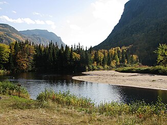
Rivière Malbaie
| Rivière Malbaie | ||
|
Rivière Malbaie in the Parc national des Hautes-Gorges-de-la-Rivière-Malbaie |
||
| Data | ||
| location | Capitale-Nationale in Québec (Canada) | |
| River system | Saint Lawrence River | |
| Drain over | Saint Lawrence River → Atlantic Ocean | |
| origin | Lac Gamache 47 ° 28 ′ 30 ″ N , 71 ° 5 ′ 35 ″ W. |
|
| Source height | 831 m | |
| muzzle | in the St. Lawrence River near La Malbaie Coordinates: 47 ° 39 ′ 18 ″ N , 70 ° 8 ′ 48 ″ W 47 ° 39 ′ 18 ″ N , 70 ° 8 ′ 48 ″ W |
|
| Mouth height | 0 m | |
| Height difference | 831 m | |
| Bottom slope | 5.2 ‰ | |
| length | 161 km | |
| Catchment area | 1849 km² | |
| Drain |
MQ |
28 m³ / s |
| Flowing lakes | Lac Malbaie | |
Rivière Malbaie is a 161 km long river in the Canadian province of Québec .
The river has its origin in Lake Gamache , located in the Réserve faunique des Laurentides , 80 km north of the provincial capital Québec . From there it flows in a northeasterly direction and flows through the Lac Malbaie . Later he turns to the southeast. This middle section of the river, in which it cuts through a low mountain range , has been protected by the Parc national des Hautes-Gorges-de-la-Rivière-Malbaie since 2000 . 120 km northeast of Québec, the river finally flows into the St. Lawrence River at La Malbaie . The catchment area covers 1849 km², the mean discharge 28 m³ / s.
Web links
Commons : Rivière Malbaie - Collection of images, videos and audio files
Individual evidence
- ↑ a b c d e Bureau Audiences publiques sur l'environnement (PDF; 103 kB)
- ↑ Commission de toponymie du Quebec - Rivière Malbaie

