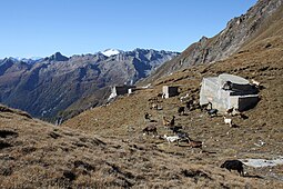
Passo del Campolungo
| Passo del Campolungo | |||
|---|---|---|---|
|
Passo Campolungo |
|||
| Compass direction | east | west | |
| Pass height | 2318 m above sea level M. | ||
| Canton | Ticino | ||
| Watershed | Riale di Tremorgio → Ticino | Riale di Val Partus → Maggia | |
| Valley locations | Prato (Leventina) | Fusio | |
| map | |||
|
|
|||
| Coordinates | 697 380 / 146905 | ||
The Passo del Campolungo is a mountain crossing in the Lepontine Alps between the Leventina in the east and the Valle Maggia and its side valley, the Val Lavizzara , in the west.
It is located at an altitude of 2318 m above sea level. M. near the Pizzo Campolungo between Pizzo del Prévat and Pizzo Meda . It is only accessible on foot, connects the Leventina Valley with the Lavizzara Valley and is located between the Leventina and Vallemaggia districts .
The pass is famous for the mighty white, sugar-like dolomite (rock) layers , which are studied by mineralogists from all over the world. The flora is also very diverse.
literature
- Mario Fransioli: Campolungo, Passo. In: Historical Lexicon of Switzerland . May 3, 2017 .
- Hike Fusio – Passo Campolungo – Tremorgio on GPS tracks
Web links
- Passo del Campolungo on ethorama


