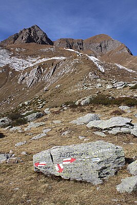
Pizzo Campolungo
| Pizzo Campolungo | ||
|---|---|---|
|
Pizzo Campolungo path |
||
| height | 2714 m above sea level M. | |
| location | Ticino , Switzerland | |
| Mountains | Ticino Alps / Lepontine Alps | |
| Dominance | 1.9 km → ridge of Pizzo Canà | |
| Notch height | 168 m ↓ at the Mognoi summit | |
| Coordinates | 698 387 / 146 151 | |
|
|
||
| rock | Two mica gneiss | |
| Age of the rock | Proterozoic to Paleozoic | |
The Pizzo Campolungo is a mountain in the Lepontine Alps in the Swiss canton of Ticino . It is located southeast of the Campolungo Pass at 2714 m above sea level. M. , with a secondary peak at 2689 m above sea level. M. The view extends to the Lago Tremorgio and the communities Prato (Leventina) and Dalpe .
geography
The peak rises on the municipal boundary of Dalpe and Prato in the Leventina district . Lago di Morghirolo is located on the southern slope and Lago di Leìt (also Laghetto Campolungo ) on the northern slope . A little southeast of the ridge is the Pizzo Lei di Cima ( 2680 m above sea level ), in the west the ridge divides to the northwest to Pizzo del Prévat ( 2557 m above sea level ) and to the southwest to Mognoi ( 2651 m above sea level). M. )
literature
- Marco Volken, Remo Kundert, Teresia Valsesia: Alpine hiking in Ticino. Lonely tours south of the Gotthard. SAC- Verlag, Bern 2004, ISBN 978-3-85902-228-7
- Around the Pizzo Campolungo on [1]
- Pizzo Campolungo at gipfelbuch.ch/tourenfuehrer/gipfel
- Pizzo Campolungo on camptocamp.org
Web links
- Pizzo Campolungo on the ETHorama platform
- Pizzo Campolungo on hikr.org
- Pizzo Campolungo on geonames.org
Individual evidence
- ↑ Passo Campolungo on ETHorama

