Passo del Ginestro
| Passo del Ginestro | |||
|---|---|---|---|
|
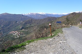
View of the Imperotal. In the background the village of Cesio and the snow-capped mountains of Piedmont |
|||
| Compass direction | west | east | |
| Pass height | 677 m slm | ||
| province | Imperia | Savona | |
| Valley locations | Cesio | Testico , Casanova Lerrone | |
| expansion | Strada provinciale | ||
| Mountains | Ligurian Apennines | ||
| profile | |||
| Ø pitch | 6.6% (165 m / 2.5 km) | 3.9% (207 m / 5.3 km) | |
| Map (Imperia) | |||
|
|
|||
| Coordinates | 44 ° 0 '26 " N , 7 ° 59' 28" E | ||
The Passo del Ginestro (Gorse Pass) connects the northern Italian provinces of Imperia and Savona . It is 5 km from Testico , 11 km from Casanova Lerrone (both Province of Savona) and 3 km from Cesio (Province of Imperia). The pass lies at 677 m slm in the Ligurian Apennines .
The pass connects the upper Imperotal with the Merulatal and Lerronetal.
Web links
Commons : Passo del Ginestro - collection of images, videos and audio files


