Pelham, Ontario
| Pelham | ||
|---|---|---|
| Location in Ontario | ||
|
|
||
| State : |
|
|
| Province : | Ontario | |
| Coordinates : | 43 ° 2 ′ N , 79 ° 20 ′ W | |
| Height : | 193 m | |
| Area : | 126.43 km² | |
| Residents : | 17,110 (as of 2016) | |
| Population density : | 135.3 inhabitants / km² | |
| Time zone : | Eastern Time ( UTC − 5 ) | |
| Postal code : | L0S | |
| Area code : | +1 905, 289, 365 | |
| Mayor : | Dave Augustyn | |
| Website : | www.pelham.ca | |
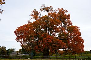
 500 year old sugar maple tree in autumn leaves |
||
Pelham is a city in the Regional Municipality of Niagara in the Canadian province of Ontario with 17,110 inhabitants (2016).
geography
The Pelham area is bounded to the south by the Welland River . The cities of St. Catharines and Niagara Falls are 15 kilometers to the northeast and 25 kilometers to the east, respectively. The Ontario Highway 406 touches Pelham in the east.
history
The town of Pelham was founded in 1970 as the amalgamation of the parishes of Fonthill , Ridgeville , Effingham , North Pelham and Fenwick . The place name goes back to the Pelham family.
Agriculture with fruit and wine-growing areas as well as medium-sized industrial companies are the dominant branches of the economy today. In addition, with the organization of various festivals, Pelham is developing into an interesting city for tourists. One attraction is the Comfort Maple Tree , named after the original owners, the Comfort family , an approx. 25 meter high sugar maple tree ( Acer saccharum ), the age of which was estimated at 441 to 541 years in 2016 and is therefore considered to be the oldest sugar maple tree in Canada is believed to be.
sons and daughters of the town
- Mike Accursi , lacrosse player
Web links
- comfort-maple - sugar maple tree
- pelhamminorhockey - Website of the Pelham Panthers ice hockey team
- pelhamsoccerclub - Website of the Pelham Red Hawks football team
