
Penelacute

The Penelakut or Penelakut First Nation lived on Vancouver Island at the mouth of the Chemainus River and the islands of Penelakut (formerly Kuper Island) and Galiano to the southeast . Today the 858 Penelakut (March 2010) have reserves on Kuper, Tent and Galiano, plus a small reserve on the lower reaches of the Chemainus.
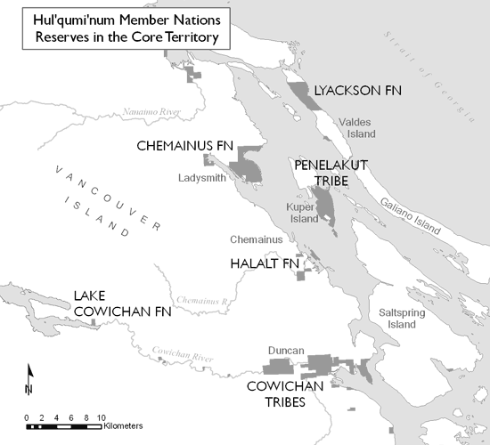
The Penelakut First Nation is one of the six tribes of the Hul'qumi'num group, including the Halalt , Chemainus , Cowichan , Lyackson and Lake Cowichan . The group represents over 7,000 Indians .
history
- see History of the Coastal Salish
Prehistory and early history
The oldest archaeological site on Salt Spring Island is Walker Hook, which is designated DfRu002 as part of the Borden system . It is one of the largest shell middens (clam mounds) in the Gulf Islands. The village of Syuhe'mun came into being there at an unknown point in time. The oldest artifacts are estimated to be 4,500 years old.
Colonial history
All Indians on Kuper Island were called Penelakut. The winter villages were on Penelakut Spit, Telegraph Harbor and Lamalchi Bay. They also had villages at Chemainus Harbor and Galiano Island. Penelakut Spit is on the northeast end of Kuper Island, and it was also the largest tribal village in the Gulf Islands . Penálaxeth , "tree trunk buried on the beach", had at least fifteen long houses. The Indian Country Commissioner Gilbert Malcolm Sproat visited the village in 1877, described it as a single nave, which, however, was divided into 15 major sections.
Telegraph Harbor on the northwest coast of Kuper Island carried the village of Xexweló7es ("place with eagles"). Today the ferries dock there, and that's where the abandoned Kuper Island Residential School is located . Its residents were united with those of Penelakut Spit in 1916.
The third winter village on Kuper Island was in Lamalchi Bay on the southwest coast. 'Lamalchi' is the anglicized form of Xwlemálhtse , which was probably not created until the beginning of the 20th century.
On April 20, 1863, the gunboat Forward shelled the village on the island because the murderers of three whites were suspected here. But the Indians defended themselves, attacked the boat and put it to flight. The governor then ordered one of the largest and most brutal acts of revenge in British Columbia's history. The Terror of the Coast by Chris Arnett (1999) describes the conflict between the Lamalchis and the Indian agents . The murder of two settlers not only gave the authorities and courts an opportunity to try and execute the suspected village men in a questionable process, but the village was destroyed in 1864 and James Douglas , the governor, forbade resettlement.
Another murder, this time of William Robinson, was, as it turned out more than 140 years later, probably wrongly accused of a penelakut. Tshuanahusset, or Tom for short, was convicted of the murder on Saltspring Island (Syuhe'mun) in March 1868 the following year by a white jury and then executed.
At Bare Point, near Chemainus Bay, stood the village of Sén'ewináts , with probably four houses, but the inhabitants were probably forced to go to Kuper Island after 1900.
The village of Xínepsem stood at Virago Point-Race Point at the northern end of Galiano Island ( Galiano Island Reservation No. 9 ) . It was probably just a summer village, but it was closely related to the Cowichan village of the same name.
Reservations
The reserves were assigned to them in 1877 by the Joint Reserve Commission under Malcolm Gilbert Sproat. The "Panel-a-kuts" with the gunboat HMS Rocket were forced to give up their residential areas in favor of Kuper Island, a barely habitable island.
Of the 858 recognized Penelakut, exactly 468 lived in the four reservations in March 2010, 72 in other reservations and 317 outside. The four reserves are Kuper Island 2 with 556.7 ha, Tsussie 6 with 15.5, Tent Island 8 with 34.4 and Galiano Island 9 with 29.1 ha.
In his report of February 15, 1877, the Indian Commissioner in charge Malcom Gilbert Sproat described his visit to Kuper Island at the "Panel-a-kuts tribe" and the sub tribes. He counted 239 Indians, 194 of them Penelakut, 28 members of the "Ga-kwa-lass sub-tribe" (Yexwelótes) and 17 of the "Kivil-la-malth-sa sub-tribe" (Lamalchi). He noticed that the Lamalchi were still a predatory and murderous tribe 12 or 15 years earlier. They attacked the gunboat "Boxer" and shot a sailor in the process. The village was shot at in revenge and three Indians were hanged. The following smallpox epidemic survived only three men of the tribe.
Sproat also reports that there is no reserve on Kuper Island and that only a white settler lives there who owned a 100 acre parcel on the site of the former Lamalcha village in the southwest. At today's Tsussie , the Penelakut owned a fishing spot .
Sproat complained that under the leadership of the Penelakut, the Indians had occupied land by white settlers. He demanded their withdrawal, which underpinned the HMS Rocket with their cannons, and refused to allow them any more reserve land at all. The Indians removed houses and fences from the occupied land, and Sproat granted them Kuper Island - with the exception of the aforementioned 100 acres . Just like Tent Island, which he also granted them, however, he considered the island to be sterile.
When the McKenna-McBride Commission visited the reservations from 1913, they suggested that the two reservations of the “Chemainus Tribe, Penelakut Band”, “No. 6 - Tsussic, 33.00 acres; No. 7 - Kuper Island, 2138.00 acres; No. 8 - Tent Island, 85.00 acres, and No. 9 - Fishing Station (at Portier Pass), * 76.00 acres “should remain. However, 4.16 acres of No. 5 were pulled in to build a lighthouse . These Commission proposals did not become legally binding until 1923.
Current situation
In 2004 a dispute broke out with the operator of a fish farm (Sablefin Hatcheries Ltd.) about a burial site on Saltspring Island , more precisely at Walker Hook. In the spring of 2003, the company was given permission to carry out construction work there without an archaeological impact assessment, as has been required since 1996 (Archaeological Impact Assessment). In addition, the company had started unauthorized construction work. The so-called Archeology branch , i.e. the archeology department of the Ministry of Sustainable Resources , investigated the breach of the law on January 13, 2004 and confirmed the illegal procedure, but this had no consequences for the company. After all, an extension of the original permit to include more shafts in 2005 was rejected. In 2004, the Salt Spring Island Residents for Responsible Land Use came together and supported the elders of the Penelakut in their fight against the destruction of the archaeological site, which a superficial examination revealed eleven burial sites and is up to 4,500 years old. The island is also home to the most significant remains of trees that have never been felled. 30% of the Garry oaks ( Quercus garryana ) of the Gulf Islands and 7.5% of the old growth known as old trees are on the island.
For several years the tribe has been trying to revive cultural traditions and offer the products to a wider audience. There are also attempts to protect the natural environment.
Remarks
- ↑ Did the wrong man hang for Saltspring murder? Mystery still surrounds 1868 killing of black settler William Robinson , in: Times-Colonist March 29, 2009 ( Memento of the original from April 1, 2009 in the Internet Archive ) Info: The archive link was inserted automatically and has not yet been checked. Please check the original and archive link according to the instructions and then remove this notice. .
- ↑ According to the information from the Department of Indian Affairs and Northern Development , First Nation Profiles: Penelakut ( memento of the original from March 6, 2016 in the Internet Archive ) Info: The archive link was automatically inserted and has not yet been checked. Please check the original and archive link according to the instructions and then remove this notice. .
- ↑ According to the information from the Department of Indian Affairs and Northern Development , First Nation Profiles: Penelakut ( Memento of the original from January 11, 2016 in the Internet Archive ) Info: The archive link was inserted automatically and has not yet been checked. Please check the original and archive link according to the instructions and then remove this notice.
- ↑ The published text: Minutes of Decision - Chemainus Tribe ( page no longer available , search in web archives ) Info: The link was automatically marked as defective. Please check the link according to the instructions and then remove this notice. .
- ^ Walker Hook is an Important Heritage Site , Salt Spring Island Residents for Responsible Land Use
- ^ Proposal for the inclusion of Salt Spring Island in the Gulf Islands National Park , News and Views of Salt Spring Island, British Columbia.
- ↑ For example the gallery Penelakut Art ( memento of the original from October 11, 2007 in the Internet Archive ) Info: The archive link was automatically inserted and not yet checked. Please check the original and archive link according to the instructions and then remove this notice. .
- ↑ To this end, the Penelakut Tribe's Strategic Management Plan was drawn up in 2003 .
literature
- Wayne Suttles (Ed.): Handbook of North American Indians . Volume 7: Northwest Coast. Smithsonian Institution Press, Washington DC 1990. ISBN 0-87474-187-4
Web links
- The Penelakut on the side of the tribal council
- Hul'qumi'num Treaty Group site
- Map of the Hul'qumi'num Contracting Group areas