
Cowichan

The Cowichan are one of the Canadian First Nations in the province of British Columbia . They live on the east coast of Vancouver Island near Duncan and culturally belong to the group of coastal Salish .
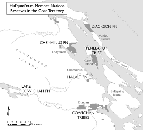
The Cowichan First Nation is one of the six tribes of the Hul'qumi'num group, which also includes the Halalt , Chemainus , Penelakut , Lyackson and Lake Cowichan . The Cowichan - not to be confused with the Lake Cowichan - make up around 60% of the group, which represents a total of over 7,000 Indians . As of August 2009, 4,338 people were registered as members of the Cowichan tribe.
In a broader sense, the Cowichan (after Franz Boas ) on Vancouver Island included: Clemchemaluts, Comiaken , Halalt , Khenipsen , Kilpanlus, Koksilah , Kuleets, Lilmalche , Malakut, Nanaimo , Penelakut , Quamichan , Siccameen, Snonowas, Somena , Tateke and Yekolaos and on the lower Fraser : Chehalis , Chilliwack, Coquitlain , Ewawoos, Katsey , Kelatt, Kwantlin , Matsqui , Musqueam , Nicomen, Ohamil, Pilalt, Popkum , Scowlitz , Siyita, Sewathen, Snonkweametl, Skawawalooks, Squawtits. Sumass , Tait , Tsakuam and Tsenes.
history
Settlement area

Originally the Cowichan lived in the lower Cowichan Valley. Its name goes back to Mount Tzuhalem (Shkewétsen), which means something like "warm back" or more plastic "basking on its side in the sun". Today's reserves are located in the lower Cowichan Valley between Duncan and Cowichan Bay, with smaller reserves further up.
The Cowichan inhabited at least twelve winter villages, considering the area as a common property. Yet each family had their own fishing grounds. Especially the area on the Koksilah River between Duncan and Cowichan Bay was densely populated. The Cowichan River with its tributaries, the Quamichan and the Somenos Creek, plus the Koksilah River opened up the region quite easily and provided the basis of life, e.g. B. Salmon and Trout .
The Garry or Oregon oak ( Quercus garryana ) and Camassia quamash were widespread here, as in the entire coastal area of southern Vancouver Island. When Oliver Wells surveyed the Cowichan Valley in 1859, he reported that "45,000 acres " could be considered "superior agricultural districts" and that the land would be sufficient to supply 500 to 600 settler families.

At Cowichan Bay there were two villages at the north end, near the mouth of the Cowichan River, two at the south end, near the point where Cowichan Bay is today. The northernmost village, Xinepsem , stood at Green Point, at the mouth of the northern arm of the Cowichan River. Edward Curtis reported 9 houses with 15 families in 1912. He also notes that the village was built in 1850. The residents must have fled from the north end of Galiano Island to escape the robbery of the southern Kwakwaka'wakw . The village of Shts'ets'mínes was near the southern arm of the Cowichan River . Curtis reports on three houses. There were two villages at the south end of Cowichan Bay. Th'íth'xwemksen stood a little north of what is now Cowichan Bay. It was closely related to the Penelakut village of the same name at Cayetano Point on Valdes Island . Cowichan Bay is now part of Theik No. 2 . The second village was called Tl'elpóles . It reached from Cowichan Bay south to Kil-pah-las No. 3 . Curtis reports on four houses.


Upstream from Green Point, on the northern arm of the Cowichan, was the winter village of Kwiemiyaken, or Comiaken . The latter name refers to the area around Comiaken Hill and the stone church built by Father Peter Rondeault in the early 1860s. In 1850 the village consisted of four long houses and about 50 families. At the junction of the middle arm of the Cowichan River, which leads to the Koksilah River, there were four villages.
Lhemlhémelets , also Clemclemalits or Clem Clem, was one of the largest villages. It consisted of ten longhouses. The southern neighbor was Xwkwó7kwxnets , northern T'aat'ka7 ( Shallon shamberry or high partridge berry ). It consisted of four longhouses and was closely connected to Lyackson Village at Shingle Point. Then there was the small village of Kwthothines, with only one or two houses, on the other side of the river, across from T'aat'ka7 . On the Koksilah River, where the highway crosses the river, was a village that is now Anglicized 'Koksilah' and whose name has been transferred to the river. In 1860 it consisted of seven long houses, but in 1912 only three. The residents owned a seasonal fishing village called Xtémten (Marble Falls) on upper Koksilah.
The largest village was halfway between Cowichan Bay and what is now Duncan. The original name, Kwómetsen , was Anglicized as 'Quamichan'. Curtis reports 32 longhouses. In 1853 at least 1,700 people must have lived there. The village stretched around 3 miles along the Cowichan River - from Quamichan Creek almost to Comiaken Village.
Above the Silver Bridge and west of the highway is the village of S7ómene or Somena . It borders directly on the south of the city of Duncan and is still called Somena Village to this day . Curtis (1913, 175) reports ten houses, but oral tradition knows more. From here the Cowichan traveled to the Fraser River and Point Roberts, but also to Koksilah Ridge in the south and Lake Cowichan in the west. 6 km above Somena there was no settlement, apart from the seasonally used fishing villages. There is z. B. the 6.5 hectare reserve Tzart-lam No. 5 .
Skutz Falls, 35 km above Somena, was originally called Skwets ('waterfall'). Where numerous Indians, including those of other tribes, met to hunt, the reservations Skutz No. 7 and Skutz No. 8 . Members of the Lake Cowichan , Cowichan, Halalt , Ditidaht and Pacheedaht met here . Cowichan Lake was a meeting place for the Cowichan and Ditidaht, and there were several houses by the falls. Marriages were also agreed here.
Raids from the north
Like most coastal Salish, the Cowichan suffered from the raids of the northern Pacific peoples and their neighbors on Vancouver Island. On Maple Bay was a village called Xwtl'epn'ts , a small seasonal village with a few houses. It was here that the last battle between the coastal Salish and the southern Kwakwaka'wakw , especially the Lekwiltok , took place in 1840. These raids ended suddenly with the smallpox epidemic of 1862 .
McKenna-McBride Commission
When the McKenna-McBride Commission visited the reservations from 1913, they suggested that from the reservations of the “Comox Tribe”, “No.1-Cowichan, 5723.00 acres; No.2-Theik, 75.00 acres; No.3-Kilpahlas, 51.00 acres; No.4-Est Patrolas (Rogers Lake), 75.00 acres; No.5-Tzartlam, 16.00 acres; No.6-Kakalatza, 24.00 acres; No.7-Skutz (A), 6:00 p.m. acres; No.8-Skutz (B), 40.00 acres; No.9-Cowichan, 48.66 acres “nothing should be severed. but she moved from No. 8 exactly 2.82 acres in favor of the Canadian Northern Pacific Railway . These Commission proposals did not become legally binding until 1923.
Current situation
The Cowichan are one of the largest Salish tribes with 4,798 (July 2015) members.
Reservations
Of the 4,356 Cowichan, exactly 2,316 lived on the reservation in September 2009, 250 on other reservations and 1,789 outside the reservations. By August 2011, their number had risen to 4,499. The nine reserves are Cowichan 1 with 2,254.1 hectares, Theik 2 on the south bank of Cowichan Bay with 30.3 hectares, Kil-Pah-las 3 with 20.6 hectares, Est-Patrolas 4 with 27.8 hectares , Tzart-Lam 5 with 6.5 ha, Kakalatza 6 with 10.5 ha, Skutz 7 with 7.3 ha, Skutz 8 with 14.9 and Cowichan 9 with 14.9 ha.
literature
- Wayne Suttles (Ed.): Handbook of North American Indians . Volume 7: Northwest Coast. Smithsonian Institution Press, Washington DC 1990. ISBN 0-87474-187-4 .
Web links
- The Cowichan on the tribal council side
- Hul'qumi'num Treaty Group site
- Map of the Hul'qumi'num Contracting Group areas
See also
- History of the Coastal Salish
- History of British Columbia
- First Nations history
- List of Indian tribes recognized in Canada
Remarks
- ↑ This and the following after: Hul'qumi'num People ( Memento of the original from December 22, 2007 in the Internet Archive ) Info: The archive link was automatically inserted and not yet checked. Please check the original and archive link according to the instructions and then remove this notice. .
- ^ Arnett 1999, 61.
- ^ Curtis 1913, 175.
- ↑ The published text: Minutes of Decision - Cowichan Tribe and Cowichan Lake Tribe ( page no longer available , search in web archives ) Info: The link was automatically marked as defective. Please check the link according to the instructions and then remove this notice. .
- ↑ ibid.
- ↑ According to the information from the Department of Indian Affairs and Northern Development , First Nation Profiles: Cowichan ( Memento of the original from April 2, 2015 in the Internet Archive ) Info: The archive link was automatically inserted and not yet checked. Please check the original and archive link according to the instructions and then remove this notice. .
- ↑ According to the information from the Department of Indian Affairs and Northern Development , First Nation Profiles: Cowichan ( page no longer available , search in web archives ) Info: The link was automatically marked as defective. Please check the link according to the instructions and then remove this notice.