
Picinguaba (place)
| Picinguaba | ||
|---|---|---|
|
Coordinates: 23 ° 23 ′ S , 44 ° 50 ′ W Picinguaba on the map of Sao Paulo
|
||
| Basic data | ||
| Country |
|
|
| State |
|
|
| Detailed data | ||
| height | 3 m | |
| Time zone | UTC −3 | |
 |
||

Picinguaba is a fishing village and district in the Brazilian municipality of Ubatuba in the state of São Paulo . The settlement is located on a small bay near the border with Paraty - RJ and 25 km east-northeast of Ubatuba as the crow flies . The village is located in the Picinguaba nature reserve . This is one of a total of eight nature reserves in the Serra do Mar National Park .
The place is home to Caiçara communities, the traditional residents of the southeast coast of Brazil. They are the descendants of indigenous tribes , Portuguese colonizers, and later African slaves. They retain a deep sense of their ancestry and cultural heritage. In Picinguaba, fishing and other elements of Caiçara's life are still well preserved.
Photo gallery
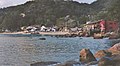
The fishing village

Canoe shelters on the beach

Residents with Caiçara canoes
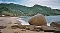
Picinguaba Beach

View from the beach bar

“Praia da Fazenda” at Picinguaba


Web links
- www.ubatuba.com.br: Picinguaba (Portuguese)
- APIS: Ação Picinguaba Sustentável (Portuguese)
- Instituto Florestal (Portuguese)
- Secretaria do Meio Ambiente (Portuguese)
- Brazil Travel: Picinguaba (English)
Individual evidence
- ↑ Picinguaba Bay is number 89 on the Ubatuba coast map
- ↑ Ministério do Turismo: Parque Estadual da Serra do Mar ( page no longer available , search in web archives ) Info: The link was automatically marked as defective. Please check the link according to the instructions and then remove this notice. (German)
- ↑ gobrazil.about.com - Picinguaba (English)