Picton River
| Picton River | ||
|
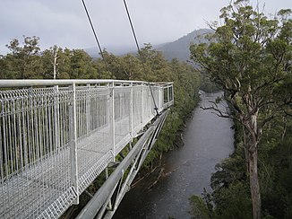
Confluence of the Picton River with the Huon River from the Tahune Forest AirWalk |
||
| Data | ||
| location | Tasmania ( Australia ) | |
| River system | Huon River | |
| Drain over | Huon River → Tasman Sea | |
| source | Pinders Peak ( Southwest National Park ) 43 ° 30 ′ 26 ″ S , 146 ° 40 ′ 58 ″ E |
|
| Source height | 881 m | |
| muzzle |
Huon River in Tahune Forest coordinates: 43 ° 5 '55 " S , 146 ° 42' 58" O 43 ° 5 '55 " S , 146 ° 42' 58" O |
|
| Mouth height | 74 m | |
| Height difference | 807 m | |
| Bottom slope | 14 ‰ | |
| length | 57.6 km | |
| Left tributaries | Roberts River , Farmhouse Creek, Cook Creek | |
| Right tributaries | Pattersons Creek, Hartz Creek | |
The Picton River is a river in the south of the Australian state of Tasmania .
geography
River course
It rises on the northern slopes of Pinders Peak in the extreme southeast of Southwest National Park . From there it flows north and in its middle reaches the western border of the Hartz Mountains National Park . East of the Southwest National Park it flows into the Huon River .
Tributaries with mouth heights
- Roberts River - 318 m
- Patterson's Creek - 241 m
- Hartz Creek - 225 m
- Farmhouse Creek - 136 m
- Cook Creek - 120 m
Tahune Forest AirWalk
At the confluence with the Huon River there is the Tahune Forest AirWalk , a system of footbridges on which you can hike just below the treetops.
Individual evidence
- ↑ a b c d Map of Picton River, TAS . Bonzle.com
- ^ Steve Parish: Australian Touring Atlas . Steve Parish Publishing, Archerfield QLD 2007. ISBN 978-1-74193-232-4 . P. 59
