
Poblat de Navetes des Turassot
| Poblat de Navetes des Turassot Talaies de Can Quiam | |||
|---|---|---|---|
 Eastern residential Naveta |
|||
Location in Mallorca |
|||
| Coordinates | |||
| place | Costitx , Balearic Islands , Spain | ||
| Emergence | 1600-1000 BC Chr. | ||

The Poblat de Navetes des Turassot ('Naveta Settlement of Es Turassot') is a prehistoric settlement on the Spanish Balearic island of Mallorca . It is located in the municipality of Costitx in the region ( comarca ) Pla de Mallorca . The Bronze Age buildings are part of the naviform section of Mallorca's history from 1600 to 1000 BC. . Chr assigned.
location
The Wohnnavetas of it Turassot located on about 160 meters above sea level, surrounded by trees near the farmhouse of Can Quiam . The distance to the center of the town Costitx in the north is 1.8 kilometers. The prehistoric building remains can be reached via the paved Camí de Son Bernat , which leads to the parking lot in front of the Astronomical Observatory of Mallorca . The latter is located 180 meters northwest of the residential navetas. An unpaved path runs south around the site of the observatory, from which you can get to Es Turassot through a wooden gate on the south side of the path along a field edge.
description

The residential navetas ( Catalan navetes d'habitació ) by Es Turassot consist of stones of different sizes that are layered on top of each other as dry stone . A total of five have been preserved, one structure cannot be interpreted. There are some olive trees on the structures, which impaired parts of the structure. The three best preserved residential navetas are lined up in the center of the complex. They are up to three meters high and their entrances face south.
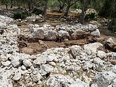
Since 2015 , annual excavations have taken place at the Poblat de Navetes des Turassot , which in the past was also known as the Talaies de Can Quiam . The previous excavation campaigns, supported by the Consell Insular de Mallorca and the municipality of Costitx, took place under the direction of Francisca Cardona López, Beatriz Palomar Puebla and Sebastià Munar Llabrés. The three central residential navetas were freed from vegetation and cleaned and the easternmost of the three lined up buildings were exposed to the ground. It is 17.21 meters long and the interior space is up to 3.65 meters wide. A wall divides the interior into two rooms with a passage on the west side. So far mainly small ceramics have been found.
- Views of the building remains
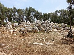
Central residential navetas
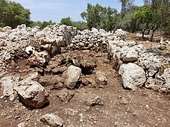
Eastern residential Naveta
Southern area of the Eastern Naveta

Northern area of the Eastern Naveta


Individual evidence
- ↑ Senderisme a Mallorca. Consell de Mallorca, accessed on July 15, 2017 (interactive map).
- ↑ Catàleg de protecció del patrimoni històric de Costitx. (PDF) Volume 3. Gabinet d'Anàlisi Ambiental i Territorial, November 2012, pp. 8–10 , accessed on July 15, 2017 (Catalan).
- ↑ Elena Ballestero: Es Turassot se revela como el poblado visitable de navetas más monumental. Ultima Hora, June 23, 2017, accessed July 15, 2017 (Spanish).
Web links
- Ruta arqueològica Sencelles-Costitx: El Poblat des Turassot. Ajuntament de Sencelles, accessed July 15, 2017 (Catalan).