Pojezierze Suwalskie
| Suwałki Lake District
Pojezierze Suwalskie
|
||
|---|---|---|
|
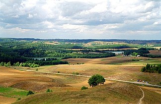
Moraine landscape near Gora Cisowa |
||
| Highest peak | Rowelska Góra ( 299 m ) | |
| location | Warmia-Masuria , Podlasie , Poland | |
|
|
||
| Coordinates | 54 ° 16 ′ N , 22 ° 49 ′ E | |

The Pojezierze Suwalskie (German about Lake District of Suwalki is) a lake landscape Polish Podlaskie . It is the westernmost part of the Lithuanian Lake District and extends partially to Lithuania and Belarus. It is located east of the Masurian Lake District in the historical Suwalszczyzna region .
location
This lake district is located in the southwest part of the Baltic Ridge . It consists of a multitude of lakes in a moraine landscape. Characteristic of this landscape are glacial channels between the hills, created by the erosive effect of the meltwater when the glaciers melted , which later took up the lakes.
Canals and shipping
Many of the lakes are connected by canals such as the Augustów Canal and rivers such as the Rospuda .
Web links
literature
- Stanisław Herz, Pojezierze Suwalskie, Wydawnictwo Kraj, Warszawa 1983
- Andrzej Ber, Pojezierze Suwalsko-Augustowskie. Przewodnik Geologiczny, Wydawnictwa Geologiczne, Warszawa 1981, ISBN 83-220-0131-2

