Poppenberg (Unterbreizbach)
|
Poppenberg
Community of Unterbreizbach
Coordinates: 50 ° 48 ′ 37 ″ N , 10 ° 1 ′ 7 ″ E
|
|
|---|---|
| Height : | 330 m above sea level NN |
| Residents : | 0 (2012) |
|
Location of Poppenberg in Unterbreizbach
|
|
|
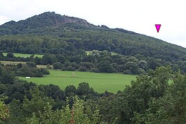
The Poppenberg farm on the northwest slope of the Öchsenberg is surrounded by old trees.
|
|
Poppenberg is an abandoned homestead in the community of Unterbreizbach in the Wartburg district in Thuringia .
location
The single farmstead Poppenberg is located south of Vacha on the western flank of the Öchsenberg near Sünna . The federal road 84 can be reached on a connecting route between Sünna and Vacha. The geographic height of the place is 330 m above sea level. NN .
history
The homestead was first mentioned on July 10, 1302 and has been uninhabited for about 20 years. It belonged to the Völkershausen court .
Web links
Commons : Poppenberg - collection of images, videos and audio files
Individual evidence
- ↑ Official topographic maps of Thuringia 1: 10,000. Wartburgkreis, district of Gotha, district-free city of Eisenach . In: Thuringian Land Survey Office (Hrsg.): CD-ROM series Top10 . CD 2. Erfurt 1999.
- ^ Wolfgang Kahl : First mention of Thuringian towns and villages. A manual. Rockstuhl Verlag, Bad Langensalza, 2010, ISBN 978-3-86777-202-0 , p. 221


