Port Orford
| Port Orford | |
|---|---|
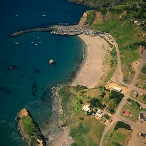
 Aerial view of the port |
|
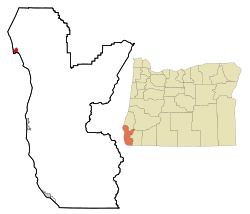
| Location in Oregon | |
| Basic data | |
| Foundation : | 1851 |
| State : | United States |
| State : | Oregon |
| County : | Curry County |
| Coordinates : | 42 ° 45 ′ N , 124 ° 30 ′ W |
| Time zone : | Pacific ( UTC − 8 / −7 ) |
| Residents : | 1,153 (as of: 2000) |
| Population density : | 278.2 inhabitants per km 2 |
| Area : | 4,144 km 2 (approx. 2 mi 2 ) |
| FIPS : | 41-59250 |
| GNIS ID : | 2411467 |
| Website : | www.portorford.org |
 Port Orford Coast Guard Station |
|
Port Orford is a small town in Curry County in the US state of Oregon . It is considered the oldest white city founding on the Oregon coast and, with the exception of Alaska, the westernmost city in the continental USA.
geography
The city is located south of Cape Blanco on the Oregon Pacific Coast. Within the city is Garrison Lake , a 52-acre freshwater lake with an adjacent wetland. US Highway 101 runs through the city .
history
Originally the region was home to the Qua-toh-mah , a Tututni tribe . In 1792 George Vancouver named today's Cape Blanco after the Earl of Orford . The name was later transferred to the place.
William Tichenor , captain of the steamer Sea Gull , deposited a small group of nine settlers on the coast in 1851, believing that the place would be suitable for the construction of a seaport. Tichenor left the place for more supplies. The Indians were able to drive out the settlers in the Battle of Battle Rock with great losses, but in July Tichenor returned with over 70 men and founded the settlement. As a result, more fur hunters, prospectors and farmers came to the region along the Rogue River . They destroyed the livelihoods of the Indians, who were defeated in the Rogue River Wars and pushed into reservations. In 1856 Port Orford was formally founded and served as the first seat of the administration of the Curry Counties, but in 1859 the administration moved to Ellensburg, which later became Gold Beach .
A forest fire destroyed Port Orford in 1868, but the city was rebuilt. The city's economic foundations were fishing, gold mining, logging, and shipping. The Lawsons cypress , which grows in the forests in the area, was also called Port Orford Cedar , the wood of which was popular for shipbuilding and house building. Dairy farming and other farms settled in the area.
Gilbert Gable came to Port Orford from New York in the 1930s . He ran mining and sawmills and tried to build a rail link inland. He operated the recognition as City , which was awarded in 1935 as the first place in Curry County. Gable became the first mayor. In October 1941, annoyed by the poor road connections and disappointed by the lack of government support, Gable ran the separation of the southern counties of Oregon and the northern counties of California to create a separate state called Jefferson . However, Gable died on December 2nd, and after the USA entered World War II on December 7th, the secessionist efforts ceased.
During World War II, the Japanese submarine I-25 cruised off Port Orford on September 9, 1942. An aircraft that was being carried threw bombs on the forests east of the city to set off forest fires. However, the plan failed.
The National Park Service lists a total of ten buildings and sites in the National Register of Historic Places for Port Orford (as of January 5, 2019), including the Port Orford Coast Guard Station .
economy
Due to the timber industry and sawmills, Port Orford experienced an economic boom until the 1970s. In the meantime, however, the timber industry has largely stopped. In addition to fishing, which is becoming less important, tourism has become the city's most important economic pillar. The port is one of the few ports in the world that has a high dock into which fishing and pleasure boats are lifted by crane. In addition to a few art galleries, the Hughes House , built in 1898 , a Victorian- style apartment building, and the 1934 Maritime Rescue Station in Port Orford Heads State Park are among the attractions. On the coast is the Battle Rock Park with the eponymous rock, which was fiercely contested in 1851. North of the city is Cape Blanco State Park with the lighthouse built in 1870 , and south of the city is Humbug Mountain State Park .
Web links
- Website of the community
- Tourism website of the Chamber of Commerce
- History of Port Orford in the Oregon Encyclopaedia
Individual evidence
- ^ The Oregon Encyclopedia: Port Orford Cedar. (No longer available online.) Archived from the original on May 20, 2011 ; Retrieved May 25, 2011 . Info: The archive link was inserted automatically and has not yet been checked. Please check the original and archive link according to the instructions and then remove this notice.
- ^ Enjoy Port Orford: Cool & Unusual Things around Town. Retrieved May 25, 2011 .
- ↑ Search mask database in the National Register Information System. National Park Service , accessed January 5, 2019.
