Portolan


The term Portolan , also called Portulan (from Italian portolano , derived from Latin portus "harbor"), originally referred to a book with nautical information such as landmarks, lighthouses, currents and port conditions.
The use of this term is first documented for the year 1285. The portolans formed the basis for the later development of the nautical books that extended to Northern Europe . From the 16th century, the meaning of the term expanded and from then on included not only the text, but also the nautical charts accompanying it. In the 19th century, scholars began to use the term "Portolan" to refer to all old nautical charts. Since the second half of the 20th century, specialists have restricted the term “portolan” to text and refer to a certain type of nautical chart as “portolan card”.
Origin and form
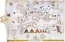
The question of their origin is controversial, but what is certain is that the medieval portolans go back to ancient descriptions of circumnavigation ( periplus , “periploi” or “limenes”). The oldest surviving portolan card , the " Pisan card ", dates from the last quarter of the 13th century. It was created at the same time as the first medieval portolan, the “ Compasso da navegare ”. The early portolans comprised mainly the Mediterranean and Black Seas . Postage rate cards from the 13th and 14th centuries are drawn on parchment and are either bound atlases or individual cards. For the larger-format single cards, the writing material animal skin was mostly retained (see illustrations).
Characteristics
An essential feature of the postage cards is the visible line network, which does not go back to the construction of the card, but is used to determine the course using a compass . This line network consists of different colored lines, also Rumbenlinien mentioned, which both from the center of the map as a uniformly distributed and of 16 on a circular line points ( " Windrosen radiate"), which is why this type of card as Windstrahlen- or Rumbenkarte is referred to. The lines of the four main and intermediate cardinal directions are black, those of the half-winds are green, those of the quarter-winds are red. This traditional color scheme has remained unchanged for more than four centuries.
use
The postage cards have a different orientation and are not always north. The seaman using the chart turned it in the direction of the particular course being followed. Dangerous passages were highlighted on the map and commented on with entries such as “Pay attention!” Or “Open your eyes”. The berths were marked in different colored ink according to their importance. If the information on the chart was not sufficient for him, the seaman could refer to the text of the portolan with its more detailed information.
See also
literature
- Uta Lindgren : Portulan . In: Lexicon of the Middle Ages (LexMA). Volume 7, LexMA-Verlag, Munich 1995, ISBN 3-7608-8907-7 , column 122 f. Originated between 1150 and 1250.
- Monique de La Roncière / Michel Mollat Du Jourdin [and a.]: Les Portulans: cartes marines du XIIIe au XVIIe siècle , Paris [u. a.] 1984, ISBN 2-09-290538-4
- Konrad Kretschmer : The Italian Portolane of the Middle Ages: a contribution to the history of cartography and nautical science , reprint of the Berlin 1909 edition, Hildesheim 1962.
- Peter Mesenburg: Postage cards prove the high art of engineers in the Middle Ages , in: Essener Universitätsberichte 2 (1988), pp. 16–21.
- Helmut Minow: Mystery of the medieval nautical charts. in: Deutsches Schiffahrtsarchiv (21–1998), pp. 411–428.
Web links
- Publications on portolan * in the Opac der Regesta Imperii
- Publications on portulan * in the Opac of the Regesta Imperii
- www.spektrum.de