
Porvenir (Chile)
| Porvenir | |||
|---|---|---|---|
 |
|||
 |
|||
| Communal data | |||
| region | Región de Magallanes y de la Antártica Chilena | ||
| province | Tierra del Fuego | ||
| founding | June 20, 1894 | ||
| Residents | 5,465 (2002) | ||
| - in cities | 4,734 | ||
| - in the country | 731 | ||
| surface | 6,982.6 km² | ||
| Population density | 1 inhabitant / km² | ||
| Post Code | 6300000 | ||
| prefix | + (56) -61 | ||
| Time zone | UTC −4 | ||
| Alkalis | Fernando Callahan Giddings | ||
| Website | |||
| main place | |||
Porvenir on the map of Chile |
|||
| Surname | Porvenir | ||
| status | Pueblo | ||
| Residents | 4,734 (2002) | ||
| surface | 2.63 km² | ||
| Population density | 1,800 inhabitants / km² | ||

Porvenir (Spanish "future" ) is both the largest Chilean settlement in Tierra del Fuego and the largest municipality in Tierra del Fuego and its administrative headquarters.
The settlement of Porvenir in Chile has the status of a pueblo , which can be translated as small town. According to the 2002 census, the city itself had 4734 inhabitants and an area of 2.63 km². Porvenir is connected to the Chilean mainland and the city of Punta Arenas by a ferry across the Strait of Magellan . The port located just outside the city is called Bahía Chilota . The city has an airport. Porvenir was founded on June 20, 1894 after immigrants from Croatia and the island of Chiloé came to Tierra del Fuego as a result of a brief gold rush . Therefore, Croatian surnames can still be found among the local population today.
A visit to the Natural Park Monumento Natural Laguna de los Cisnes and the city's historical museum is recommended . The Alberto De Agostini National Park is 80 kilometers south of the city . Here are the huge calving glaciers De Agostini and Marinelli .
The climate is oceanic . The warmest months of January and February have an average temperature of 10 ° C, the coldest July and August 2 ° C.

Detail from a monument on the main square
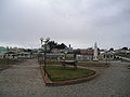
Parque Yugoslavo

port

Church of St. Francisco de Sales


