
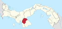
Herrera Province
| Herrera | |
|---|---|
  |
|
| Data | |
| Capital | Chitré |
| population | 113,000 |
| surface | 2,341 km² |
| Population density | 48 people / km² |
| structure | 7th |
| ISO 3166-2 | PA-6 |
Herrera is a province in Panama named after the former General Tomás Herrera . The capital of Herrera is Chitré , which is about seven kilometers inland from the Gulf of Panama . The approximately 8,000 hectare Sarigua National Park is also located in Herrera.
The province was founded on January 18, 1915 from parts of the Los Santos province .
The Herrera Province is divided into seven districts ( distritos ):
The main economic factors in Herrera are the cultivation of sugar cane and dairy and cattle farming, but also industry and trade.
Web links
Provinces: Bocas del Toro | Chiriquí | Coclé | Colón | Darién | Herrera | Los Santos | Panamá | Panamá Oeste | Veraguas
Territories: Emberá-Wounaan | Guna Yala | Ngöbe-Buglé - without provincial status: Kuna de Madugandí | Kuna de Wargandí
Coordinates: 8 ° 0 ′ N , 80 ° 36 ′ W