
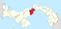
Panamá Oeste Province
| Panamá East | |
|---|---|
  |
|
| Data | |
| Capital | La Chorrera |
| population | 464.038 |
| surface | 2,786 km² |
| Population density | 170 people / km² |
| structure | 5 distritos |
| ISO 3166-2 | PA-10 |
The Panamá Oeste Province is the youngest of ten provinces in the Republic of Panama in Central America . The capital of the province is La Chorrera .
The province lies on the Pacific coast on the Gulf of Panama and is bordered to the east by the Panama Canal .
This youngest province in the country was created through the separation of the five districts of the province of Panama west of the Panama Canal . The corresponding law came into effect on January 1, 2014.
The five districts ( distritos ) - divided into a total of 59 corregimientos - are (the main places in brackets) ':
- Arraiján District (Arraiján)
- Capira District (Capira)
- Chame District (Chame)
- La Chorrera District ( La Chorrera )
- San Carlos District ( San Carlos )
proof
- ↑ telemetro.com ( Spanish )
Provinces: Bocas del Toro | Chiriquí | Coclé | Colón | Darién | Herrera | Los Santos | Panamá | Panamá Oeste | Veraguas
Territories: Emberá-Wounaan | Guna Yala | Ngöbe-Buglé - without provincial status: Kuna de Madugandí | Kuna de Wargandí
Coordinates: 8 ° 55 ′ N , 79 ° 45 ′ W