
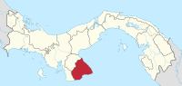
Los Santos Province
| Los Santos | |
|---|---|
  |
|
| Data | |
| Capital | Las Tablas |
| population | 92,000 |
| surface | 3,805 km² |
| Population density | 24 people / km² |
| structure | 7th |
| ISO 3166-2 | PA-7 |
Los Santos has a province in Panama and is located on the Gulf of Panama on the Azuero -Halbinsel,
The capital of the province is Las Tablas . The main economic factors in Los Santos are cattle farming and agriculture and, increasingly, tourism on the more than 200 kilometers long Pacific coast . The small island of Isla Iguana in the Pacific also belongs to the province of Los Santos .
Los Santos is known for the production of the pollera , a typical traditional costume of Panama.
The province of Los Santos is in turn divided into seven districts ( distritos ):
- Guarare
- Las Tablas
- Los Santos
- Macaracas
- Pedasí
- Pocrí
- Tonosí
Web links
Provinces: Bocas del Toro | Chiriquí | Coclé | Colón | Darién | Herrera | Los Santos | Panamá | Panamá Oeste | Veraguas
Territories: Emberá-Wounaan | Guna Yala | Ngöbe-Buglé - without provincial status: Kuna de Madugandí | Kuna de Wargandí
Coordinates: 7 ° 30 ′ N , 80 ° 30 ′ W