Pune (Cantonment)
| Pune Cantonment | ||
|---|---|---|
|
|
||
| State : |
|
|
| State : | Maharashtra | |
| District : | Pune | |
| Location : | 18 ° 41 ′ N , 73 ° 44 ′ E | |
| Residents : | 71,781 (2011) | |
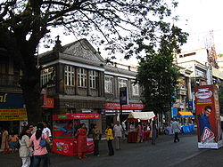
| MG Road shopping street | ||
Pune Cantonment is a cantonment in the Indian state of Maharashtra . It forms a suburb of the metropolis of Pune . Despite its name, the cantonment is not part of the municipality of Pune, but forms an independent administrative unit.
The settlement is part of the Pune District . Pune Cantonment has the status of a Cantonment Board . The city is divided into 8 wards . It had a total of 71,781 inhabitants on the cut-off date of the 2011 census, of which 37,046 were men and 34,735 were women. Hindu form with a share of approximately 57% of the largest group of people in the city followed by Muslims with about 23%, Christians with about 8%, Buddhist with about 5% and Jain with about 3%. The literacy rate in 2011 was 93.6%.
The Pune Cantonment was established in 1817 to house troops of the British-Indian Army. It is still home to many military installations today. It is also known for its many shopping areas such as MG Road and East Street . The headquarters of the Indian Army's South Command is in Pune Cantonment. The National War Memorial Southern Command, which commemorates fallen soldiers in the Indian armed forces, is also located here.

