Pyhrner Kampl
| Pyhrner Kampl | ||
|---|---|---|
|
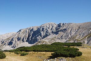
Pyhrner Kampl, north-west side |
||
| height | 2241 m above sea level A. | |
| location | Upper Austria , Styria , Austria | |
| Mountains | Warscheneck Group , Dead Mountains | |
| Dominance | 1 km → Schrocken | |
| Notch height | 38 m ↓ Elmscharte | |
| Coordinates | 47 ° 38 '56 " N , 14 ° 11' 54" E | |
|
|
||
| rock | Dachstein limestone , main dolomite | |
The Pyhrner Kampl is 2241 m above sea level. A. high mountain in the Dead Mountains on the border of Upper Austria and Styria . The mountain forms a long, partly rocky, partly rugged mountain ridge, which is connected to the southwest by a narrow ridge over the Elmscharte to Schrocken . The west summit with its north and west wall forms the end of the Rottal valley. The east summit sends a sharp rock ridge into the Luigistal, from where it appears as a boldly shaped horn. Several climbing routes up to level IV lead through the north face . At the summit there is a summit cross with a summit book.
Ascent
Marked climbs to the shock . From the Elmscharte the ridge north immediately to the west summit.
- Route 217 from the Hutterer Höß over the north ridge
- Route 219 from the Liezener Hütte over the Hochmölbing
literature
- Gisbert Rabeder: Alpine Club Leader Dead Mountains . For hikers, mountaineers and climbers, Bergverlag Rudolf Rother , June 2005, ISBN 3-7633-1244-7
Web links
Commons : Pyhrner Kampl - Collection of images, videos and audio files

