
Q'umarkaj

Q'umarkaj (also written Cumarcaj or Gumarcaah ) is a pre-Columbian temple and palace city of the Maya tribe of the Quiché in the highlands of Guatemala . The name means 'place of the old bundles of reeds'. Other names of the place are 'Utatlan' ( nahuatl ) or 'Quiché Viejo' ( Spanish ).
location
Q'umarkaj is located on a wooded mountain plateau that is surrounded by ravines and is therefore easy to defend about 22 kilometers north of Chichicastenango at an altitude of about 2200 meters and can be easily reached via paved but winding roads. The closest town is Santa Cruz del Quiché (approx. 2.5 kilometers east).
history
Q'umarkaj was founded around 1400 by the - possibly mythical - ruler Q'uq'umatz (= Quetzalcoatl or 'feather snake') and by his successors who, with the help of the allied Cakchiquel -Maya, also over large parts of southern Mesoamerica up to today's El Salvador ruled and expanded. After a revolt, the Cakchiquel left the city around 1470 and founded their own capital, Iximché , about 50 kilometers southeast (as the crow flies) .
In 1524 the Spanish conquistador Pedro de Alvarado conquered the Quiché empire at the head of about 420 horsemen and Indian auxiliaries ( Tlaxcalteken and Cakchiquel); the leader of the Quiché Army, Tecun Uman , was killed. The rulers of the Quiché invited Pedro de Alvarado to visit their capital, but he set up camp in front of the city. Now, in turn, he invited the Quiché leaders, but shortly after their arrival he had them arrested. After the death of one of his soldiers by rebelling Indians, he had the prisoners burned on a stake and then set the whole city on fire.
Rediscovery
The city was abandoned but never completely forgotten. Francisco Ximénez , the translator of Popol Vuh , visited the place at the end of the 17th century . In 1834, Miguel Rivera y Maestre wrote a report for the government and in 1840 John Lloyd Stephens and Frederick Catherwood visited the ruins. At the end of the 19th century, Alfred Maudslay documented the place. Excavation and restoration work was carried out in the 1950s but, given the large number of stones reused in the construction of the neighboring town of Santa Cruz del Quiché, they got stuck.
architecture
Actually, only three buildings of the entire complex of Q'umarkaj are of interest: the temple pyramids of Tohil and Avilix and the ball playground .
- Temple pyramid of Tohil
- Described by Francisco Ximenez in the late 18th century as the tallest building in the entire complex and drawn by Frederick Catherwood in 1840 as a towering structure with three external staircases, most of the existing structure has disappeared. The name refers to a deity who brought fire to the Quiché and held the rank of city or tribal patron.
- Temple pyramid of Avilix
- The Temple of Avilix is a good example of a largely unrestored pyramid, on the structure of which one can nevertheless recognize the steps of the Talud-tablero system. The god Avilix is sometimes identified with Ixbalanqué , one of the 'Divine Twins' of Popol Vuh .
- Ball court
- The Q'umarkaj ball court is one of four whose traces have been found on site. All have the typical H-shaped floor plan and are sloping towards the middle playing area; the side parts of the playing field have neither a slope nor a marker stone - other rules may have applied here.
- Palaces
- Almost nothing has been preserved from the palace buildings of the upper class; some of the platforms they once stood on are still recognizable.
- caves
- To protect against attacks, three simple tunnel caves were carved into the limestone cliffs in the area, where old people, women and children could hide.
Popol Vuh
The founding of the city of Q'umarkaj is described in the Popol Vuh, the holy book of the Quiché - albeit with legendary decoration. The gods Tohil and Avilix are also mentioned there.
photos
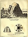
Catherwood - Sketch of Tohil Temple (1840)

Catherwood - terracotta figures (1840)
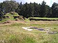
Temple of Avilix

Temple of Tohil

.jpg)


Others
In the immediate vicinity of the former capital, the ruins of four satellite cities were discovered: Chisalin (400 meters north), Pismachi (600 meters south), Atalaya (600 meters east) and Pakaman (1600 meters east). They could all have served as an upstream line of defense.
See also
Individual evidence
- ↑ Popol Vuh. The book of the council. Diederichs, Munich 1990, p. 146f, ISBN 3-424-00578-9
- ↑ Popol Vuh. The book of the council. Diederichs, Munich 1990, p. 111ff and p. 154ff, ISBN 3-424-00578-9
literature
- Robert M. Carmack and John M. Weeks: The Archeology and Ethnohistory of Utatlan: A Conjunctive Approach. American Antiquity ( Society for American Archeology ) 46 (2), 1981, pp. 323-341.
- Joyce Kelly: An Archaeological Guide to Northern Central America: Belize, Guatemala, Honduras, and El Salvador. University of Oklahoma Press 1996. ISBN 0-8061-2858-5 . OCLC 34658843.
Web links
- Q'umarkaj - Photos + Info (English)
Coordinates: 15 ° 1 '24.7 " N , 91 ° 10' 19.2" W.