Chichicastenango
| Chichicastenango | ||
|---|---|---|
|
Coordinates: 14 ° 57 ′ N , 91 ° 7 ′ W Chichicastenango on the map of Guatemala
|
||
| Basic data | ||
| Country | Guatemala | |
| Department | El Quiché | |
| City foundation | 1872 | |
| Residents | 107,193 (2002) | |
| Detailed data | ||
| surface | 400 km 2 | |
| Population density | 268 inhabitants / km 2 | |
| height | 2000 m | |
| Flower market on the steps of the Santo Tomás Church | ||
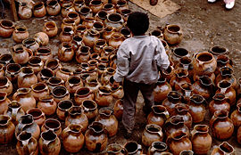
| Pottery in the market in Chichicastenango | ||
| Santo Tomás Church | ||
Chichicastenango or Santo Tomás Chichicastenango is a city with about 30,000 and a municipality with a total of about 105,000 inhabitants in the department of El Quiché in the central highlands of Guatemala .
Surname
The name Chichicastenango comes from the Nahuatl of the Tlaxcaltek auxiliary troops of the Spanish conquerors, who named the city Tzitzicaztenanco ("city of nettles") after a nettle species ( Chichicaste grandis ) growing here . The name of the place in the Quiché language is Chaviar .
Location and climate
The city of Chichicastenango is located about 1 km west of the Río Motagua and about 10 km north of its source in the mountains of the Sierra Madre at an altitude of about 2000 m about 137 km (driving distance) northwest of Guatemala City or about 94 km east from Quetzaltenango , the second largest city in the country. The climate is temperate to warm; Rain (approx. 1095 mm / year) falls almost exclusively in the summer half-year.
population
At the 2002 census, the Chichicastenango parish had 107,193 inhabitants. About 95% of the population identified themselves as belonging to the indigenous Maya people of the Quiché and 5% as Ladinos .
history
Chichicastenango was an important religious and political center for the Quiché Indians . After the conquest by the Spanish conquistador Pedro de Alvarado in 1524, the Spaniards destroyed the old Mayan temple and built the church of Santo Tomás on its base. To this day, however, the church is also used by Mayan shamans and healers (curanderos) who light incense and candles on the floor, blow schnapps over them and offer flower offerings. The 18 steps of the staircase, which may still come from the old Mayan temple, correspond to the months of the Mayan calendar . The town was elevated to a town (villa) in 1872.
Attractions
- The city's street network, which runs at right angles, dates from the Spanish colonial era. But it is also possible that the Indians who previously lived here knew a similar system.
- The market that takes place every Thursday and Sunday in the square in front of the Santo Tomás Church is the largest in the country and attracts not only local traders and buyers from the Quiché tribe but also Mam , Ixil , Cakchiquel and many tourists. In its center there are numerous cookshops with local dishes.
- For the feast of St. Thomas , the Quiché brotherhoods perform the dance of the Tzijolaj horse , to which flowers, candles, incense and rum are offered in honor; it is now a tourist attraction.
Others
In Chichicastenango in 1702, Father Francisco Ximénez discovered the manuscript of the Mayan book Popol Vuh , of which he made a copy and a Spanish translation; the original of the work has disappeared.


