Quellenweg (Fichtelgebirgsverein)
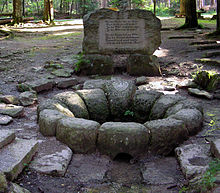
The Quellenweg is a 46 km long main hiking trail in the Fichtelgebirge , which connects the four sources of the main rivers Saxon Saale , Eger , Weißer Main and Fichtelnaab .
Route
Description of the route from north to south: City of Münchberg - village of Kleinlosnitz - Markt Zell im Fichtelgebirge - source of the Saxon Saale - peat bog hell - Eger spring - Solitude Karches - Weißmain spring - Fichtelnaab spring - Fichtelsee - Nagler See - village Nagel - village Reichenbach - Luisenburg near Wunsiedel - Bad Alexandersbad - Marktredwitz .
The spring migration not only touches the catchment areas of the Elbe, Danube and Rhine rivers, but also crosses the main European watershed between the North Sea and the Black Sea.
The hiking trail is created and supervised by the Fichtelgebirgsverein . The marker for the path is a black Q in a yellow rectangle.
hiking map
- Fritsch hiking map No. 52 Fichtelgebirge Nature Park, 1: 50,000, 17th edition (Landkartenverlag Fritsch, Hof / Saale)
literature
- Julius Neidhardt: hiking guide through the Fichtel Mountains . VI. Edition 1987.
- Dietmar Herrmann, Helmut Süssmann: Fichtel Mountains, Bavarian Vogtland, Steinwald, Bayreuther Land. Lexicon . Ackermannverlag, Hof (Saale) 2000, ISBN 3-929364-18-2 .

