Quisberg
| Quisberg | ||
|---|---|---|
|
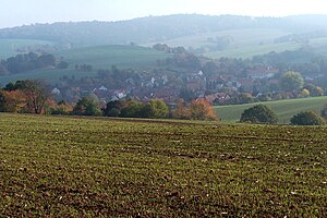
View from the south over Unterellen with Quisberg (upper left half of the picture), which extends as far as the location. |
||
| height | 291.9 m above sea level HN | |
| location | Thuringia ( Germany ) | |
| Mountains | Thuringian Forest | |
| Coordinates | 50 ° 58 '14 " N , 10 ° 10' 10" E | |
|
|
||
| rock | Red sandstone | |
The Quisberg is a 291.9 m high elevation and is located in the corridor of the Unterellen district in the municipality of Gerstungen in the Wartburg district in Thuringia . In terms of nature, the Quisberg is part of the south-western part of the Thuringian Forest .
An unpaved road leads north over the Quisberg as a connecting route to the neighboring towns of Göringen , Wartha and Neuenhof . This route is part of an old trade route from Frankfurt via Fulda, Werra crossing at Phillipsthal (formerly Kirchberg), Wünschensuhl, Unterellen (previously via Flensingen), Wartha / Neuenhof towards Eschwege, Kassel, northern Germany. In the vernacular the mountain is called Quesbig, which is derived from Queste and can be traced back to Slavic influence. 19th century cartographers who were ignorant of the dialect translated what they had heard into High German and took away its original meaning. Further examples from the Untereller Flur are hd.Böller -mundartlich Biller from ahd.bilu = something excellent; Marktberg - vernacular Mötbäg from Am-Ort-Berg (the local mountain).
Individual evidence
- ↑ Official topographic maps of Thuringia 1: 10,000. Wartburgkreis, district of Gotha, district-free city of Eisenach . In: Thuringian Land Survey Office (Hrsg.): CD-ROM series Top10 . CD 2. Erfurt 1999.

