Río Alhárabe
|
Río Alhárabe Río Moratalla |
||
|
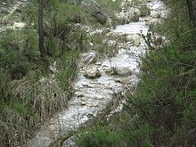
The Río Alhárabe near Moratalla |
||
| Data | ||
| location | Murcia Province | |
| River system | Segura River | |
| Drain over | Río Segura → Mediterranean | |
| source | in El Sabinar, Moratalla municipality 38 ° 12 ′ 50 ″ N , 2 ° 9 ′ 26 ″ W |
|
| Source height | 1200 msnm | |
| muzzle | at Calasparra in the Río Segura coordinates: 38 ° 15 '36 " N , 1 ° 42' 54" W 38 ° 15 '36 " N , 1 ° 42' 54" W. |
|
| Mouth height | 275 msnm | |
| Height difference | 925 m | |
| Bottom slope | approx. 19 ‰ | |
| length | approx. 50 km | |
| Drain |
MQ |
200 l / s |
| Right tributaries | Río Benamor | |
| Small towns | Moratalla , Calasparra | |
The Río Alhárabe is a river in the region of Murcia in Spain . It is a right tributary of the Río Segura .
location
The 50 km long river has its source near El Sabinar in the area of the municipality of Moratalla in the province of Murcia . From the confluence of the Río Benamor , it is also known as the Río Moratalla . It flows off to the east and flows into the Río Segura above Calasparra .

