Río Cifuentes
| Río Cifuentes | ||
|
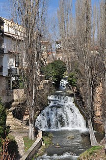
Waterfall of the Río Cifuentes in Trillo |
||
| Data | ||
| location | Guadalajara Province , Spain | |
| River system | Tagus | |
| Drain over | Tagus → Atlantic | |
| source | at Cifuentes 40 ° 47 ′ 4 ″ N , 2 ° 37 ′ 17 ″ W |
|
| Source height | approx. 890 m | |
| muzzle | at Trillo in the Tajo Coordinates: 40 ° 42 ′ 4 " N , 2 ° 35 ′ 31" W 40 ° 42 ′ 4 " N , 2 ° 35 ′ 31" W |
|
| Mouth height | approx. 730 m | |
| Height difference | approx. 160 m | |
| Bottom slope | approx. 11 ‰ | |
| length | approx. 15 km | |
| Catchment area | approx. 200 km² | |
| Communities | Cifuentes , Trillo | |
The Río Cifuentes ( cifuentes = "hundred springs") is an approximately 15 km long tributary of the Tajo in the landscape of the Alcarria in the province of Guadalajara in the region of Castile-La Mancha in central Spain .
course
The Río Cifuentes rises from several source streams (arroyos) ; however, the rock below the castle (castillo) of Cifuentes is often considered its actual source . At first it flows south and crosses the south of the municipality; at the place Gargoles de Abajo it turns to the southeast in order to - coming from the north - flow into the Tajo at the place Trillo .
Tributaries
Except for a few streams, the Río Cifuentes has no tributaries.
Places on the river
Cifuentes and Trillo
Shore landscape
The surrounding area is mostly mountainous and rocky. Hikes along the river bank are only possible over short distances. There is fishing for trout (truchas) .
