Río Puela
| Río Puela | ||
|
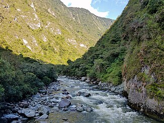
Lower reaches above Palictahua |
||
| Data | ||
| location | Chimborazo Province in Ecuador | |
| River system | Amazon | |
| Drain over | Río Chambo → Río Pastaza → Río Marañón → Amazon → Atlantic Ocean | |
| Confluence of | Río Laurel and Río Naranjal 1 ° 31 ′ 40 ″ S , 78 ° 24 ′ 43 ″ W |
|
| Source height | approx. 2950 m | |
| muzzle |
Río Chambo Coordinates: 1 ° 31 ′ 13 ″ S , 78 ° 31 ′ 6 ″ W 1 ° 31 ′ 13 ″ S , 78 ° 31 ′ 6 ″ W. |
|
| Mouth height | approx. 2300 m | |
| Height difference | approx. 650 m | |
| Bottom slope | approx. 41 ‰ | |
| length | 16 km (including source rivers: 33 km) | |
| Catchment area | approx. 230 km² | |
| Discharge A Eo : 185 km² Location: 9 km above the mouth |
MQ Mq |
17.6 m³ / s 95.1 l / (s km²) |
The Río Puela is a 16 km (including headwaters 33 km) long right tributary of the Río Chambo in the province of Chimborazo in central Ecuador .
River course
The Río Puela drains part of the western flank of the Cordillera Real . It arises at the confluence of the Río Naranjal and Río Laurel southeast of the Tungurahua volcano . The Río Puela flows in a predominantly westerly direction along the southern flank of the Tungurahua. The Río Puela finally flows into the north-flowing Río Chambo, 17.5 km above its junction with the Río Patate to the Río Pastaza . 1.3 km above the estuary, the E490 ( Riobamba - Ambato ) road crosses the Río Puela.
Hydrology
The catchment area of the Río Puela extends between the volcanoes Tungurahua in the north and El Altar in the south. It covers an area of 230 km². The mean discharge about 9 km above the mouth is 17.6 m³ / s.
Individual evidence
- ↑ A. Laraque, J. Ronchail et al. a .: Heterogeneous Distribution of Rainfall and Discharge Regimes in the Ecuadorian Amazon Basin. In: Journal of Hydrometeorology. 8, 2007, p. 1364, doi : 10.1175 / 2007JHM784.1 .
