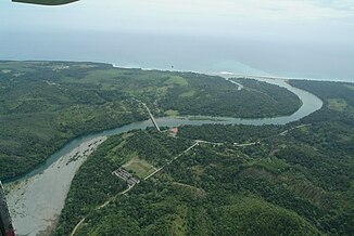
Río Toa
| Río Toa | ||
| Data | ||
| location | Guantanamo Province , Cuba | |
| River system | Río Toa | |
| source | in the Nipe Sagua Baracoa Mountains | |
| muzzle | in / near Baracoa in the Atlantic Coordinates: 20 ° 23 '24 " N , 74 ° 31' 51" E 20 ° 23 '24 " N , 74 ° 31' 51" E
|
|
| length | 131 km | |
| Catchment area | 1061 km² | |
The Río Toa is the most water-rich river in the island state of Cuba . The stream with a length of 131 kilometers has 72 tributaries and lies entirely in the province of Guantánamo .
It rises from the Nipe Sagua Baracoa Mountains and is located in the Cuchillas del Toa Biosphere Reserve , which also includes the Alexander von Humboldt National Park . In the reserve, the average annual rainfall is around 2,800 m, which is the highest value in Cuba.
The catchment area of the Toa River extends over 1061 km 2 .
See also
Individual evidence
- ^ A b c Hunt, Nigel: Toa River, the mightiest river in Cuba . 2009. Retrieved October 2, 2009.
- ^ The Columbia Gazetteer of North America. 2000
- ↑ Toa River at patrimoniodecuba.com ( page no longer available )
- ↑ El Gavilán Caguarero (Chondrohierax uncinatus) en las Aves de Cuba ( Spanish ) Guije.com. Retrieved January 18, 2011.
