
Retention basin shot
| Retention basin shot | |||||||||
|---|---|---|---|---|---|---|---|---|---|
 |
|||||||||
|
|||||||||
|
|||||||||
| Coordinates | 52 ° 7 '29 " N , 11 ° 33' 9" E | ||||||||
| Data on the structure | |||||||||
| Construction time: | 1968-1971 | ||||||||
| Height above valley floor: | 6 m | ||||||||
| Height above foundation level : | 7 m | ||||||||
| Crown length: | 277 m | ||||||||
| Crown width: | 3 m | ||||||||
| Slope slope on the air side : | 1: 2 | ||||||||
| Slope slope on the water side : | 1: 2.5 | ||||||||
| Data on the reservoir | |||||||||
| Total storage space : | 39,000 m³ | ||||||||
| Catchment area | 49 km² | ||||||||
| Particularities: |
Extensive renovation 1995–1999 |
||||||||

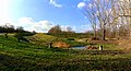
The retention basin Schrote (local name also: Schrotestau ) is used today for flood protection of the city of Magdeburg , especially of the district of Diesdorf and is located between the places Niederndodeleben and Magdeburg on the western border of the urban area of Magdeburg. The shot is dammed up during high water. The building was once designed as an irrigation water reservoir for agriculture with a permanent storage volume of approx. 10,000 m³. However, this use never occurred. The system is now managed by the Saxony-Anhalt dam company.
construction
The retention basin was built from 1968 to 1971 as a straight two-zone dam made of gravel sand with a sealing core made of loess clay. A 145 m long trench is located on the air side of the dam to discharge the seepage water, which opens into the shot below the stilling basin . The material for the support structure and core was removed approx. 1 km above the barrier structure. A maintenance path runs along the trench.
Project planning and construction
The rain retention basin Schrote was planned in 1967 by the VEB Projektierung Wasserwirtschaft external office in Magdeburg under the name flood protection basin Schrote. The project consisted of the parts
- Part 1 - Expansion of the shot and road construction,
- Part 2 - dam construction, ramp ramp and overflow structure with bottom outlet.
In 1967 the project documents were received from the Magdeburg branch of the state building supervision (part 1, building permit No. 179/67 of December 19, 1967) and the Dresden branch of the state building supervision for dams (part 2, building permit No. 34/67 of December 24, 1967) September 1967) checked without complaints.
Construction contractors were VEB Tiefbau Magdeburg Oberbauleitung Gardelegen and VEB Meliorationsbau Magdeburg. The construction costs amounted to around 1,100,000 GDR marks. The economic feasibility study assumed an annual benefit of approx. 92,000 marks for the GDR as the benefit to be expected by preventing flood damage. The former VEB (K) Wasserwirtschaft had empirically determined up to two mean shot floods per year with an average damage of 184,000 MDN , which had already been assessed as "certainly too high" when the task for the design planning of the flood protection basin was given.
In connection with the construction of the flood protection basin and the accompanying construction measures, 73 trees had to be felled, 6 of which had a trunk diameter of 70–80 cm. In the area of the areas required for the extraction of building material for the barrier structure, the cherry plantation was on the pork corner. It has been completely cleared.
Operating facilities
Bottom discharge and removal device
The bottom outlet with a capacity of 1.7 m³ / s is located in the southern half of the dam. On the other hand, a capacity of over 3 m³ / s was designed, but this cannot be achieved because the transition from the Mönchsbauwerk to the bottom outlet was only made with pipes with a nominal diameter of 1,000 mm instead of pipes with a nominal diameter of 1,000 mm, as a study in 1978 showed .
Flood relief system

The retention basin has a flood relief system. On the southern side of the dam, near the bottom outlet, runs an approx. 55 m long concrete overflow channel, designed as an open trapezoidal channel. This is followed by an approx. 110 m² stilling basin, behind which the flood relief merges into the shot.
Control and measuring devices
Structural supervision
In 2006, a borehole that was once drilled for the purpose of a stability study was expanded as a groundwater observation pipe in order to be able to monitor the seepage lines. A trench runs parallel to the airside maintenance route, which enables seepage water measurements.
Level system
A pressure level is used to monitor the storage space.
Biotope
Apart from the occasional mowing of the grass on the dam and the reed beds directly at the foot of the dam, there is essentially no maintenance or management of the facility. Fauna and flora in the flood protection basin are therefore largely left to their own devices. Mainly reed spreads massively. Although the free water area is decreasing from year to year due to increasing siltation, the flood protection basin forms a settlement area for many bird species, such as the reed warbler , mallards , great crested grebes and resting and resting place for a number of migratory birds. The gray heron and kingfisher were seen in 2016
Flood discharge on the southern side of the dam near the bottom outlet

Panorama south-north with bottom outlet and flood relief

Panorama north-south
