
Ramenstein Cave
| Ramenstein Cave
|
||
|---|---|---|
 Ramenstein Cave |
||
| Location: | Nattheim , Baden-Württemberg , Germany | |
| Height : | 570 m above sea level NN | |
|
Geographic location: |
48 ° 42 '19 " N , 10 ° 13' 33" E | |
|
||
| Cadastral number: | 7227/01 | |
| Geology: | White Jura ζ | |
| Type: | Passage cave | |
| Discovery: | 1904 | |
| Lighting: | no | |
| Overall length: | 45 m | |

The Ramenstein Cave is a 45 meter long, U-shaped through cave in the Lindletal near Nattheim in the Baden-Württemberg district of Heidenheim .
Geographical location
The 1904 discovered cave is located in a Ramenstein called White Jura - rocks on the right slope of the Lindletales, around 500 meters from the western entrance of Nattheim. The cave entrances are located 30 meters above the valley floor and the federal road 466 running there at 570 m above sea level. NHN .
topography
The Ramenstein Cave is almost exclusively laid out on transverse fissures and has numerous bulges, crevices as well as ceiling and crevice chimneys. Ceilings and the shape of the profiles indicate that it is the remains of a formerly larger river cave that was destroyed and removed when the Lindletal was formed.
The southern entrance of the cave connects from the west to a 2.5 meter high, 6 meter wide and 1.5 meter deep abri . The cave passage has a slight slope for the first 5 meters to the west and then branches off to the north. After another 5 meters, it zigzags over a length of 27 meters and then turns into an ascending, increasingly narrowing corridor that runs straight to the east. The northeast entrance here was bricked up in 1985 - with the exception of a small opening - to protect the wintering bats . From November to April the southwest cave entrance is also closed with a gate.
Research history
In 1904 the first excavations were carried out under the rock shelter and the southern part of the almost completely filled cave was excavated over a length of 20 meters. In 1930/31 the work was continued, several rock bars were blasted out and the remaining sediments were cleared up until the north-eastern entrance broke through. The loamy excavation was tipped down the slope directly in front of the cave and can still be seen there today. In addition to medieval shards of vessels , the bones of mammoths , woolly rhinos , cave bears , cave hyenas , wolves , horses and reindeer were recovered and identified.
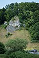
The Ramenstein
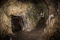
Look into and out of the cave
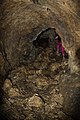
The walled-up northeast entrance from the inside ...

... and from the outside


literature
- Hans Binder, Herbert Jantschke: Cave guide Swabian Alb . DRW-Verlag, Leinfelden-Echterdingen 2003, ISBN 3-87181-485-7 , p. 80.
- Hans Binder, Herbert Jantschke, Peter Heinzelmann, Karl-Heinz Pfeffer: Karst and Cave 1993, Karst Landscape Swabian East Alb . Association of German Cave and Karst Researchers V., Munich 1993, ISSN 0342-2062 , pp. 158-161.
- Fritz Weidenbach: Annual books for karst and cave studies - karst and caves in the Brenz and Lone area (Swabian Alb) . Association of German Cave and Karst Researchers V., Munich 1960, pp. 44-46.