
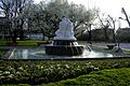
Rapoldi pond
| Rapoldi pond | ||
|---|---|---|

|
||
| Island in the pond | ||
| Geographical location | Tyrol , Austria | |
| Drain | artificial runoff into the sill | |
| Places on the shore | innsbruck | |
| Data | ||
| Coordinates | 47 ° 15 '57 " N , 11 ° 24' 22" E | |
|
||
| Altitude above sea level | 575 m above sea level A. | |

The Rapoldi-Weiher is located in the same Rapoldipark in Innsbruck district Pradl serving as the recreation center was expanded. The tram line 3 stops in front of the park. In addition to the Ambras Castle Park and the Hofgarten , the Rapoldipark is the third largest in Innsbruck.
The lake has both an artificial water inlet, which feeds water from the Sill underground, and a 70 m long drain back into the river. The water provides a protected habitat for various duck and carp species .
- Rapoldi pond
Rapoldi fountain

source
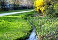
Seebach discharge


