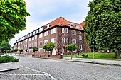
Rathausstrasse (Cuxhaven)
The Town Hall Street in Cuxhaven is approximately 0.5 km long road. It leads in an east-west direction from Blohmstrasse / Grüner Weg to Stresemannplatz.
Back streets
The side and connecting streets are named Blohmstraße after Anna Blohm, whose husband laid the street, Grüner Weg as early as 1740 after a field path that was built on from 1845, Werner-Kammann-Straße 1985 after Lord Mayor Werner Kammann (1919–1984) , Rathausplatz after the Cuxhaven town hall, Stresemannplatz 1929 and 1945 after the statesman and Foreign Minister Gustav Stresemann (1878–1929) (1935–45 Saarlandplatz ) and Catharinenstraße 1894 after the mothers of the builders of the street Catharina Höpcke and Catharina Wendt and Poststraße after the post office that stood by the road until 2000.
history
Surname
The street was named in 1927 after the town hall that it passes by.
development
After Ritzebüttel and Alt-Cuxhaven were united in 1872 , the local area was expanded to a greater extent. In 1907 Cuxhaven received city rights. In 1917 the two-storey, clinkered, representative town hall was inaugurated. The building received additional wings several times (1931, 1939, 1973 and 2006). The road was expanded around 1927. Rails of the Cuxhaven tram from 1913 were in place until 2009. In 1953 the square in front of the town hall on the Grüner Weg was redesigned
In terms of traffic, the street is affected by the bus lines 1018 (Poststraße) as well as 1007 and 1010 (Rathausplatz) of the KVG .
Buildings, plants (selection)

On the street there are mostly three- to four-story clinker brick buildings from the 1920s and 1930s, mostly with hipped roofs . The houses marked with a D are under monument protection.
- No. 1: Three and four-story town hall ( D )
- Citizen's office in Cuxhaven opposite the town hall
- No. 14a – c: Three-story residential buildings on Rathausplatz
- Rathausplatz as the green area of a large Wehl or Kolks that was created before 1530 when the dike broke and was filled in 1953
- Nos. 14 to 22: houses and offices
- No. 21: Four-storey building from 1932 of the school inaugurated in 1935 (formerly known as the Rathausschule ) with grades 7 to 10, today 5 to 10, named in 1932/33 and from 1949 as Bleickenschule after Bleick Max Bleicken (1869-1959) first mayor from 1907 to 1931
- No. 21: Cuxhaven City Theater from around 1980 with 350 seats in the existing school building; is played by a changing ensemble
- Döser Speeldeel in the city theater since 2013
- No. 21: Gorch-Fock-Schule, an open all-day primary school
- No. 23: Four-storey residential building
- No. 31/33: four-storey residential buildings
Web links
Individual evidence
- ↑ Cuxpedia: roads .
- ^ List of architectural monuments in Cuxhaven
Coordinates: 53 ° 52 ′ 6.1 " N , 8 ° 41 ′ 46.8" E

