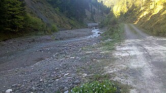
Rauhensackbach
| Rauhensackbach | ||
|
Rauhensackbach with barriers at an altitude of approx. 1000 m |
||
| Data | ||
| location | Upper Bavaria | |
| River system | Danube | |
| Drain over | White Valepp → Valepp → Grundache → Brandenberger Ache → Inn → Danube → Black Sea | |
| source | Northwest slopes of Schinder 47 ° 36 ′ 46 ″ N , 11 ° 51 ′ 2 ″ E |
|
| Source height | 1492 m | |
| muzzle |
White Valepp Coordinates: 47 ° 37 ′ 36 " N , 11 ° 50 ′ 26" E 47 ° 37 ′ 36 " N , 11 ° 50 ′ 26" E |
|
| Mouth height | 980 m | |
| Height difference | 512 m | |
| Bottom slope | approx. 19% | |
| length | approx. 2.7 km | |
The Rauhensackbach in Bavaria arises from several ditches on the northwest slopes of the Schinder . Near Bernaustube it flows largely northwards into the White Valepp .
Individual evidence
Commons : tributaries of the Inn - collection of images, videos and audio files
- ↑ Roughly measured on the Bavaria Atlas.
Web links
- The course of the Rauhensackbach on the BayernAtlas
