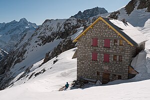
Refuge du Soreiller
| Refuge du Soreiller STD hut |
||
|---|---|---|
| location | Isère department ; Auvergne-Rhône-Alpes , France | |
| Mountain range | Pelvoux | |
| Geographical location: | 44 ° 57 '37.4 " N , 6 ° 14' 37.3" E | |
| Altitude | 2730 m | |
|
|
||
| owner | Société des Touristes du Dauphiné | |
| Construction type | hut | |
| accommodation | 0 beds, 94 beds | |
| Winter room | 40 bearings | |
The Refuge du Soreiller at an altitude of 2719 m is a refuge in Pelvoux in the French department of Isère in the Auvergne-Rhône-Alpes region .
description
The refuge is built under the imposing silhouette of the Aiguille Dibona in Pelvoux . It belongs to the Société des Touristes du Dauphiné (Dauphine Tourist Association).
Access
The refuge can be reached by taking the road from Saint-Christophe-en-Oisans to La Bérarde and stopping 3 km before the site. From there it's about three hours uphill in a northerly direction.
Summit ascents
The hut is the starting point for several mountain tours to the following mountains:
- Aiguille du Plat de la Selle - 3596 m
- Tete du Rouget - 3418 m
- Aiguille Orientale du Soreiller - 3382 m
- Aiguille Centrale du Soreiller - 3338 m
- Aiguille Occidentale du Soreiller - 3280 m
- Aiguille Dibona - 3131 m
Web links
- Section: Refuge du Soreiller (French)
- Hut side: Refuge du Soreiller (French)
- Camptocamp.org: Refuge du Soreiller (French)
- Hikr.org: Refuge du Soreiller (German)
- Refuges.info: Refuge du Soreiller (French)
- Skitour.fr: Refuge du Soreiller (French)

