Reischenau
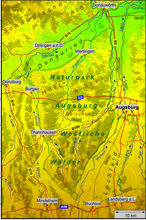
The Reischenau is the middle part of the Augsburg-Westliche Wälder nature park . Unlike the adjacent very wooded landscapes - the perennial south, and the Holzwinkel north of Reischenau - she was formerly a vast area of marshland in one of the together created basin. The name derives from the boggy landscape and the Reischen (rushes) growing there, which has been handed down from the 11th century (Rischinaowa) and 13th century (Rischenawe).
The Reischenau is drained by the Reichenbach , the Kleine Roth and the Zusam, into which both flow and which the Reischenau flows through in a large east arch.
The largest places in Reischenau are
- in the district of Augsburg
- in the municipality of Dinkelscherben : Dinkelscherben, Anried , Breitenbronn , Ettelried , Fleinhausen , Häder , Lindach , Oberschöneberg and Ried ;
- in the municipality of Kutzenhausen : Kutzenhausen, Agawang , Buch and Maingründel ;
- in the community of Ustersbach : Ustersbach and Mödishofen;
- in the district of Günzburg
- in the community of Ziemetshausen : Schönebach .
The federal highway 300 is roughly the southern border of the Reischenau to the perennials.
Sights in Reischenau
- Dinkelscherben local history museum
- Remains of Zusameck Castle near Dinkelscherben
- the preserved fen areas of the Reischenau with some rare animal and plant species
Web links
Individual evidence
- ^ Kapfhammer, Günther (1982): Landscapes of the Augsburg region. In: Annual Report of the Heimatverein für der Landkreis Augsburg eV (14), pp. 119–148.
Coordinates: 48 ° 20 ′ 1 ″ N , 10 ° 34 ′ 25 ″ E
