Resurrection Bay
| Resurrection Bay | ||
|---|---|---|
|
View from Resurrection Bay to Bear Glacier |
||
| Waters | Harding Gateway (Pacific Ocean) | |
| Land mass | Kenai Peninsula (mainland North America) | |
| Geographical location | 59 ° 58 ′ N , 149 ° 23 ′ W | |
|
|
||
| width | approx. 17 km | |
| depth | approx. 35 km | |
| Islands | Fox Island , Rugged Island , Hive Island | |
| Tributaries | Resurrection River , Bear Glacier | |
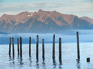
The Resurrection Bay is a bay in the US state of Alaska to the Kenai Mountains on the Kenai Peninsula , east of Kenai Fjords National Park . The only town in the bay is Seward at the north end.
Alexander Baranow , then head of the Russian-American Company , gave Resurrection Bay its name after finding refuge there from a severe storm in the Gulf of Alaska . The storm was on a Easter Sunday after Baranov and chose the name "resurrection" (Engl .: Resurrection ) for the bay and the nearby Resurrection River .
On the east side of the bay are Thumb Cove , Sandspit Point , Sunny Cove , Driftwood Bay and Safety Cove five state marine parks , on the west side at Fort McGilvray, an abandoned fortress from the Second World War , is the Caines Head State Recreation Area . During the war, the fort was a strategic defensive fortification for the port of Seward and the southern terminus of the Alaska Railroad . The fort should repel any invasion by the Japanese army . The Bear Glacier lies at the transition from the bay to the open sea .
The opening scene of the film The Hunt for Red October , which in Murmansk - Fjord played, was shot in the bay.


