
Richtenberger See
| Richtenberger See | ||
|---|---|---|

|
||
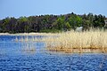
| Richtenberger See (2011) with a view of Richtenberg | ||
| Geographical location | Mecklenburg-Western Pomerania , Vorpommern-Ruegen district | |
| Tributaries | Lock trench, further trenches | |
| Drain | Blind Trebel | |
| Islands | 2 | |
| Places on the shore | Richtenberg , Franzburg , Müggenhall | |
| Data | ||
| Coordinates | 54 ° 11 '39 " N , 12 ° 52' 59" E | |
|
||
| Altitude above sea level | 9.48 m above sea level HN | |
| surface | 1.3 km² | |
| length | 1.87 km | |
| width | 1.02 km | |
| Maximum depth | 2.7 m | |
|
particularities |
drained between 1936 and 2006 |
|

The Richtenberger See (also: Franzburg-Richtenberger See ) is a lake between the towns of Franzburg and Richtenberg in Western Pomerania . The watercourse, which was drained in 1936 , was recreated as part of an ecological compensation measure for environmental damage that occurred during the construction of Federal Highway 20 .
geography
The lake has an area of about 130 hectares with a maximum extension of about 1.8 kilometers in a west-east direction and one kilometer from north to south. There are two islands in it. The water level is about ten meters above that of the sea. Richtenberg is to the north and Franzburg to the south . The border between the two cities runs through the lake. The Schleusengraben is one of several tributaries from the east. On the south-western bank of the lake is the outflow of the lake into the Blinde Trebel . The drain is designed in the form of a fish ladder , which overcomes a height difference of 3.8 meters. Also in the southwest that borders the conservation area at Hellberge.
Hiking, cycling and riding trails have been laid out around the lake.

history
The lake was first mentioned in the 13th century, although it is not clear whether it was of natural origin or was created by monks from the nearby Neuenkamp monastery in today's Franzburg. The area was drained in 1936 by the Reich Labor Service . Before the flooding in 2006, there were wet meadows that were criss-crossed by drainage ditches opening into the lock ditch. To design the surroundings of the Franzburg-Richtenberger See, the Franzburg-Richtenberg Office decided to create a Local Agenda 21 .
A dispute over the name of the lake has broken out between the towns of Franzburg and Richtenberg. The Richtenbergers insisted that, for historical reasons, the lake only had to be named after its location.
Recovered fauna and flora

Drainage of the lake


Nature reserve
Since 2016, the lake and its banks have been under nature protection as the Richtenberger See nature reserve.
Web links
Individual evidence
- ↑ level Franzenburg - Richtenberger See - 04759.5
- ↑ State Office for the Environment, Nature Conservation and Geology MV: Evaluation of fish passages in Mecklenburg-Western Pomerania - inventory analysis (PDF file), p. 41
- ↑ Information on amt-franzburg-richtenberg.de , accessed on July 26, 2017
- ↑ https://www.lung.mv-regierung.de/daten/steckbrief_n329.pdf