
Leading light line Sandstedt
| Leading light line Sandstedt | ||
|---|---|---|
 |
||
| Place: | Sandstedt | |
| Location: | Lower Saxony , Germany | |
| Geographical location: | 53 ° 21 '40.3 " N , 8 ° 30' 38.3" E | |
| Fire carrier height : | 17 m (lower fire) 35 m (upper fire) |
|
| Fire height : | 15 m (lower fire) 23 m (upper fire) |
|
|
||
| Identifier : | Oc.W.6s | |
| Function: | Leading light | |
| Operating time: | since 1981 | |
| International ordinal number: | B 1297 (lower fire) B 1297.1 (upper fire) |
|

The leading light line Sandstedt is a leading light on the Lower Weser . It marks the fairway between Brake and Harriersand .
Lower and upper fire
The 17 meter high lower light consists of a white steel tube with a red pyramidal roof. It stands directly on the banks of the Weser on the beach of Sandstedt . The 35 m high top light is 420 m inland behind the dike and consists of a red and white striped steel tube. The two beacons were put into operation in 1981 to replace the old leading lights. They form a leading light line of 21 ° and show a synchronous white interrupted fire with a return of six seconds (Oc.W.6s).
Former leading lights
The first leading lights in Sandstedt were erected in 1898 as part of the Weser correction and were in operation until 1981. The upper fire was on a 19 m high, triangular iron lattice tower with a clad staircase, gallery and lantern. After a renovation, the fire carrier became the property of the municipality of Sandstedt as a monument.
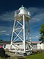
The lower fire stood on a 11.3 m high, triangular lattice beacon with a round gallery and lantern. It was dismantled in Sandstedt and re-erected in 1983 as an exhibit in the German Maritime Museum.
The new sub-fire
The old sub-fire

The old top fire


Web links
- Russ Rowlett: Lighthouses of Germany: Bremen ( English ) In: The Lighthouse Directory . University of North Carolina at Chapel Hill . Accessed May 1, 2019.
- Erich Hartmann: Leading light Sandstedt. In: German beacons.