Rio Claro (Sao Paulo)
| Rio Claro | |
|---|---|
|
Coordinates: 22 ° 25 ′ S , 47 ° 34 ′ W
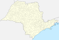
Rio Claro on the map of Sao Paulo
|
|
| Basic data | |
| Country | Brazil |
| State | São Paulo |
| City foundation | June 10, 1827 |
| Residents | 186.253 (IBGE / 2010) |
| City insignia | |
| Detailed data | |
| surface | 498 km² |
| height | 613 m |
| City structure | 121 districts |
| Time zone | UTC −3 |
| City Presidency | João Teixeira Junior ( DEM ) |
| Website | |
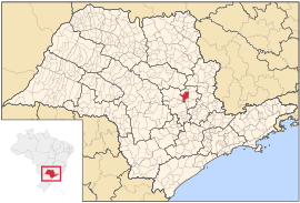
| Location of the city of RioClaro in the state of São Paulo | |
Rio Claro is a city in the interior of the Brazilian state of São Paulo with 206,424 inhabitants (2019). The city is located at 47 ° 33 'West and 22 ° 24' South, in the greater Piracicaba region at a distance of 190 kilometers from the city of São Paulo . The municipal area covers an area of 490 km².
Originally founded with the name São João Batista do Ribeirão Claro , the city was renamed São João do Rio Claro and then in 1905 Rio Claro in the course of its history .
climate
In a tropical climate, the city has an average temperature of 18 to 22 ° C. The hottest month is February with an average temperature of 22 ° C, with the average maximum being 30 ° C.
In the city is the Horto Florestal Edmundo Navarro de Andrade . This park is a forest that was planted by the railway company to have a raw material reservoir. In this forest Edmundo Navarro de Andrade planted eucalyptus trees that he had brought with him from Australia in 1914. In the following years he researched the eucalyptus there.
Sons and daughters
- Fernando Antônio Brochini (* 1946), religious, Catholic bishop of Itumbiara
- Carla Tiene (* 1981), former tennis player
Individual evidence
- ↑ a b IBGE : Cidades @ São Paulo: Rio Claro. Retrieved August 29, 2019 (Brazilian Portuguese).


