Riverside Albert
| Riverside Albert | ||
|---|---|---|
 The Consolidated School of Riverside-Albert |
||
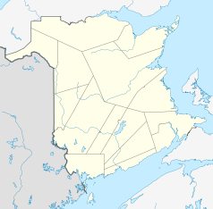
| Location in New Brunswick | ||
|
|
||
| State : |
|
|
| Province : | New Brunswick | |
| County: | Albert County | |
| Coordinates : | 45 ° 45 ′ N , 64 ° 44 ′ W | |
| Area : | 5.74 km² | |
| Residents : | 350 (as of 2016) | |
| Population density : | 61 inhabitants / km² | |
| Time zone : | Atlantic Time ( UTC-4 ) | |
| Area code : | +1 506 | |
| Foundation : | 1996 | |
| Website : | www.riverside-albert.ca | |
Riverside-Albert is a small Canadian town in Albert County , New Brunswick with 350 inhabitants (as of 2016). The parish was created in 1996 through the merger of two smaller parishes, Riverside and Albert.
Riverside-Albert is on the Shepody River near the settlement of Harvey. Riverside Albert is roughly halfway between the two tourist attractions Fundy National Park and the Hopewell Rocks .
The Trans Canada Trail runs through Riverside-Albert.
Web links
Commons : Riverside-Albert - collection of images, videos and audio files
