Ropaži
| Ropaži | ||
|---|---|---|
 Help on coat of arms |
|
|
| Basic data | ||
| State : |
|
|
| Landscape: | Livonia ( Latvian : Vidzeme ) | |
| Administrative district : | Ropažu novads | |
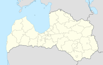
| Coordinates : | 56 ° 58 ' N , 24 ° 38' E | |
| Residents : | 1,686 (Jun 3, 2015) | |
| Area : | ||
| Population density : | ||
| Height : | 40 m | |
| Website: | www.ropazi.lv | |
| Post Code: | ||
| ISO code: | ||
Ropaži (German: Rodenpois ) is a place in Latvia , about 34 km northeast of Riga , and the center of the district of the same name (Ropažu novads).
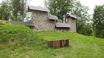
The place lies on the banks of the Jugla and was already settled by the Livs , from whose language the place name is derived. Mentioned in a document as early as 1205, a castle of the Teutonic Order existed here until the 16th century , the ruins of which can still be visited today.
In the 19th century, the Protestant pastor family Walter worked here; the Lutheran pastor Reinhold Wilhelm von Walter (1840–1909) was born here.
Since the 19th century, Ropaži has been the capital of a municipality that became part of the current district in 2009.

Ruins of the Rodenpois Ordensburg
literature
- Hans Feldmann , Heinz von zur Mühlen (Hrsg.): Baltic historical local dictionary, part 2: Latvia (southern Livland and Courland). Böhlau, Cologne 1990, ISBN 3-412-06889-6 , pp. 514-515.
- Astrīda Iltnere (ed.): Latvijas Pagasti, Enciklopēdija. Preses Nams, Riga 2002, ISBN 9984-00-436-8 .
