Rosebud (South Dakota)
| Rosebud | |
|---|---|
|
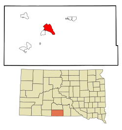
Location in South Dakota
|
|
| Basic data | |
| State : | United States |
| State : | South Dakota |
| County : | Todd County |
| Coordinates : | 44 ° 14 ′ N , 100 ° 51 ′ W |
| Time zone : | Central ( UTC − 6 / −5 ) |
| Residents : | 1,587 (as of 2010) |
| Population density : | 47 inhabitants per km 2 |
| Area : | 33.9 km 2 (approx. 13 mi 2 ) of which 33.8 km 2 (approx. 13 mi 2 ) are land |
| Postal code : | 57570 |
| Area code : | +1 605 |
| FIPS : | 46-55940 |
| GNIS ID : | 1257470 2393213, 1257470 |
Rosebud ( Lakota : Sičháŋǧu) is an American settlement in Todd County South Dakota . The settlement serves as the administrative seat of the Rosebud Indian Reservation . It is the largest settlement in the reserve area. Rosebud is not a community in the sense of American law, but a census-designated place a 'settlement area defined for statistical purposes'.
According to a 2010 census, the population was 1587. Of these, 93.38% were members of the Sioux tribe of the same name . The name rosebud (rosebud) comes from the wild roses that grow in the area. Rosebud has bases for the Indian Health Service, the Bureau of Indian Affairs (BIA), the Tribal BIA Police and the BIA Fire Management.
Web links
Commons : Rosebud (South Dakota) - Collection of pictures, videos, and audio files
Individual evidence
- ^ Jan F. Ullrich: New Lakota Dictionary , 2nd. Edition, Lakota Language Consortium, Bloomington, IN 2014, ISBN 978-0-9761082-9-0 . Archived from the original on October 18, 2016 Info: The archive link was inserted automatically and has not yet been checked. Please check the original and archive link according to the instructions and then remove this notice. (Accessed June 10, 2016).
